Connect to Data, AutoCAD Map - Bentley Map
In this post I want to make a comparison of the ways in which it is accessed databases with the geospatial platforms of AutoDesk and Bentley.
I have used it to:
- AutoDesk Civil 3D 2008 (Which includes AutoCAD Map)
- Bentley Map V8i
| AutoCAD Civil 3D 2008 | Bentley Map V8i |
Connect:  File, connect to Data ... |
Connect: 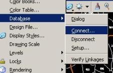 Settings, database, connect |
 |
 |
|
AutoCAD concentrates here all the alternatives of connection with data:
Additionally from Import you can access:
|
Bentley here only maintains the connections with Databases:
From the Raster manager data is accessed: From Import you access to:
From Open it is accessed to:
|
|
Can not access data:
Although some of these can be via ODBC. |
In general, the two tools have almost the same functionalities, although in the case of AutoDesk it concentrates them more in a single connection panel to data services. In the case of Bentley some of them are from the raster manager, import and open.
In this AutoCAD is in better condition than Bentley, at least in access to MySQL data and ArcSDE And MapGuide, without having to resort to artilfugios via ODBC.
And in terms of OGC standards, AutoCAD has the advantage of accessing wfs, although with wms in time it is ahead of it because Bentley does it until this V8i version while AutoCAD did it from before ... record, I'm not using the 2009 version. Even so, in this both platforms have lagged behind, considering that low-cost or free tools do it in abundance ... let's not say serve data.
To open or import data AutoDesk has more than Bentley Map as being, we put some basic examples although this is not understood as connecting to data because it has to be imported.
Regarding raster formats, AutoCAD has less than Microstation, but those that usually store elevation data, AutoCAD has some more commonly used ones, such as those from ESRI. AutoDesk overcomes the fact of "connecting" to data, while what Bentley does is "call reference." Both are incipient in radar capture formats, very few to say nothing.