
Download street maps from Google Earth
To our knowledge, there is no program (yet) that can download Google Earth streets in vector format. Although you can from Open Street Maps, too bad there are not from all cities.
But if someone is interested in the streets of Google Earth, then the way out is to download them as an image, and then vectorize like hell on them. Here are some tips to decrease the level of savagery:
1. Put a black background image
We do this, so that the satellite image does not obstruct and improves the visibility of the streets. A black bmp image is made in Mspaint and it is called from Google Earth, stretching it over the area of interest.
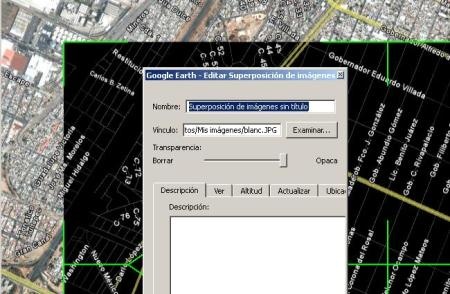
2. Download the image with Stitchmaps

Now using Stitchmaps, we chose a mosaic that allows us to see texts of a thickness less than the vector of the street.
See how, although Google Earth did not see all the streets at the height of the image, Stitchmaps are all, we choose a lower elevation, in this case 384 meters.
Once the mosaic is defined, we order to download, and wait for the mosaic to conform. finally we save it with tiff format, and with a calibration file for OziExplorer (.map). The image looks like this: the image on the right is an enlargement:

As a parenthesis, if we want to convert it to .ecw, in Global Mapper we bring it in, assign projection to it and tell it to rectify it from a .map file. Then it can be exported to .ecw for better handling from another program.

3. Scan it with a plotting program
Draw line by line could be half annoying, if you want to move fast, you can use an automatic plotting program, such as Microstation Descartes.
 It is understood that the .ecw image is georeferenced, (although it could be done from Descartes), what comes is to convert the image to a vector, with the same procedure that we show in a previous post.
A mask is made for the yellow tones, and another for the gray tones and then we tell it to convert them to a vector with topological cleaning. The segment where the text is, the vector will not be created, we will have to make the union on foot, although if you want to take advantage of Descartes, it is possible that he will convert all those tones of the text to the gray of the street, that's why it we made it smaller. If the text is to be vectorized, use the command for oriented text.
4 In case of not having Microstation Descartes
It should also work similar with AutoDesk Raster Design, ArcScan, Manifold GIS, and even Corel Trace.


The article is from 2009 and focused on the need to do it with the Trace function - from Microsation. There are other articles in which it has been explained how to do it from OSM using QGIS.
and why do not you use qgis and you avoid that many steps and work
They cite you here compatriot: http://geomarketingspain.blogspot.com/
Hello Javier, Inkscape is a very functional alternative to Corel Draw
Beautiful post,
I add Inkscape (free) to vectorize
Greetings to you