LADM - As Unique Model of the Land Administration Domain - Colombia
Summary of presentation made by Golgi Alvarez and Kaspar Eggenberger at the Andean Geomatics Congress in Bogotá, in June 2016.
Requirement for the Multipurpose Cadastre
With the implementation of the National Development Plan 2014 - 2018 and the creation of the National Land Agency ANT, the landscape for the field of Lands in Colombia has changed considerably and has put new elements for the construction of the cadastral policy as they are :
- Decentralization of the cadastre with the delegation of powers to the territorial level,
- Outsourcing of the execution of the establishment and cadastral maintenance.
- To reach a coherence of the predial information in the databases of Cadastre and Registry,
The Project Modernization of Land Administration in Colombia, financed by the Swiss Cooperation (SECO), supports different processes related to land policy, including support for the construction of a land administration node within the framework of the ICDE, the support for the restructuring and institutional reorientation of the IGAC regarding its new role as cadastral authority, the strengthening of the Cadastral-Registration policy, advice for the geodetic reference framework and also support for the realization of the vision of the Multipurpose Cadastre.
The LADM Model
As an innovative element in the policy and technology framework, the adoption of the International Land Management Standard called ISO-19152 has begun; I know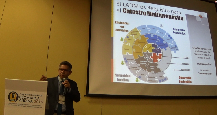 LADM (Land Administration Domain Model). The incorporation of this standard allows a balance between the pressure generated by the technological offer and the demand for services by citizens in matters of territorial management under an integrated approach.
Currently, a first version of the LADM core model has been built, adapted to Colombian legislation that includes modeling at least:
- The interested parties, be these groups, natural persons, legal entities and public entities linked to the chain of administration of rights of the earth,
- The administrative units that represent the different territorial objects, both private and public.
- The list of rights, responsibilities and restrictions that exist between the territorial objects and the real property registered in the Property Registry.
- The spatial units and their attributes, which exist in the current cadastral information and, which will be raised in the Multipurpose Cadastre pilots to be executed soon.
- The adoption of the LADM also includes support for the Colombian Spatial Data Infrastructure (ICDE), through the creation of the Land Administration Node, which will serve as the basis for the interoperability of the elements modeled in the core. Gradually, the different institutions will adapt the LADM in their processes, guaranteeing the unique reference to the goods, rights, people and taxes that make up the machinery of the National Land Management System of Colombia.
INTERLIS to implement it
 One of the instruments that is being used for the implementation of the LADM is INTERLIS. This is a specialized language for the description of geographic data models, which has a transfer format and a series of tools with which the validation, integration, transactional management and updating of information can be achieved through interoperability protocols.
A training has recently been developed for technicians from the different institutions linked to the Project, on the use of INTERLIS for modeling, and a version of the Colombian LADM model has been developed in this language.
The Multipurpose Cadastre Pilots
The Project is supporting the Agustín Codazzi Geographical Institute (IGAC) and the National Registry Superintendency (SNR), in the construction of the model, technical specifications and procedures for the development of the Multipurpose Cadastre Pilots. This includes the implementation of a repository for the storage of cadastral and registry data; with free software tools that facilitate the construction, editing and publication of data, as well as tools for the validation of the data generated through outsourced execution.
In addition, technical and didactic materials will be prepared for the different activities of the field process and the building survey.
Through the LADM Colombian Profile Implementation Model, described in INTERLIS, contractors will have at their disposal the necessary tool to prepare  and deliver the information collected in the field according to the aforementioned standard model of the ISO 19152 Standard. The IGAC and the SNR will have available the tools for verification, control and storage of the information and documents of the pilot results, to generate the lessons learned and improve the methodology for evaluating the products of the cadastral survey.
More information about the Project in http://www.proadmintierra.info/