
MapInfo: Yesterday, today and maybe tomorrow

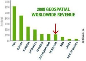
MapInfo is software that has been popularized on a regular basis as a competitive alternative to ESRI's domain. Much has been written about this tool, I want to dedicate this post to reviewing trends rather than capabilities, which according to the Daratech 2008 study appears in seventh place based on 2008 sales and sixth in terms of traditional GIS . How I would like to know what participation the platforms have open source Which now have a good level of maturity.

|
 |
Yesterday: An alternative to ESRI
MapInfo emerged in the 80's to compete from an alliance with Microsoft against the two extremes that meant ArcView and Workstation Arc / Info; both coming from the UNIX environment, one simpler than despicable and the other extremely astral as it will always be considered. Thus, in this panorama, MapInfo appears as a slightly cheaper solution than ArcView, with a friendlier appearance because it resembles Windows but with versions for both Macintosh and UNIX.
Meanwhile, the rest was in other waves, Bentley was insignificant before the geofumadas that Meant Intergraph, AutoDesk he was fighting his CAD world, GE SmallWorld didn't even exist in dreams (and if it weren't for GE it wouldn't exist). The one that did exist was ERDAS, which now acquired by Leica and added to the other accessories appears in sixth place.
For the time I just Windows 95 Appears We were surprised very simple things but that were wonderful in MapInfo, like the button e To stop hanging processes, Zoom preview, changes in directories without losing the link, transparencies, ease of associating one to many and many to many. Things that ArcView 2.1 didn't do, let alone the creation of contour lines, that with the Vertical Mapper integration MapInfo could do, and that only Arc / Info handled but we already know at what cost (between $ 10,000 and $ 20,000).
Then MapInfo at that time was a great alternative to the tyranny of the ArcView 2x can, followed the battle until 3x and then appeared a mental lagoon that few remember what it consisted.
Today, a robust tool
MapInfo users defend it tooth and nail, although they know its weaknesses (in versions prior to 9) in the treatment of images, it is accepted that for the generation of output products (maps for printing) it is wonderful. Very attractive some AutoCAD-style functionalities, such as layer control and vector editing, among the things that have amazed me the most, personally is the export to pdf with control of layers, In which layers can be turned off or on with a side panel.

What happens is that MapInfo became a public company, and depending on who has more shares is complicated when compared with private companies like ESRI and Bentley, to give two examples. Therefore, to see MapInfo you have to consider these different phases: before version 7, before version 8 and before version 9. Hence the rigor in its Lifecycle of products.
 If we measured Mapinfo against ArcView 9x (without extensions), they go to the penalty kicks, and it beats it in terms of functionality. If we measured it with manifold, it loses in terms of geofumados and price, but it beats in the generation of exit products and friendly environment. So MapInfo is a great tool, very robust in OGC standards, it is complemented with MapBasic, MapXtreme and Routing for building custom applications not only for desktop but for the web.
At the client level, Mapinfo supports WMS, WFS, SFS and GML; while as MapMarker server, MapXtreme and Envinsa do their tricks. MapXtreme is both a client and a server.
The redesign of version 10 is a great smoke, based on the previous versions but gives me the impression that they turned it like an ice cream vendor's sock. It can be seen, rather than updating the interface, a great effort to make many weaknesses of previous versions come true, including its interaction with Postgre and PostGIS is very significant.
Maybe tomorrow
The bad thing about all this is that being a public company, and acquiring the majority of shares for PitneyBowes, MapInfo happens to be One more tool the large company that does not have GIS as a priority. What PitneyBowes is looking for is a tool with which it can make geospatial adaptations to its location platforms, so the purchase could be more harmful than beneficial for the tool.
 My omen is negative, but it is what does not happen to a private company, where its creator not only sees the money it can generate but also the pride of having seen it born and not unless the economic crisis is unbearable, it is not his first exit sell to the highest bidder or liquidate due to non-productivity.
Hopefully this is not the case, because their market share is significant and more than a market, they are customers who expect to maintain loyalty in both directions. Many tools that I have talked about here, like CadCorp y Manifold GIS They would like to have that privilege.


What kind of opinion?
Mapinfo is a powerful tool to develop spatial data capture and analysis processes. But it will depend on what you think you are being asked to give you a suggestion.
regards
What kind of opinion?
Mapinfo software is a robust application, if you want to capture or analyze spatial data.
I am developing a project for the school that asks me to use mapinfo for the area of coffee production
They could give me their point of view
Well I agree on the negative omen. I stayed in the 6 version, and now that I'm looking for information from Mapinfo, the change of address is completely noticeable. However, the new approach does not fit me at all, I have lost in a sea of meaningless paragraphs.