
Portable GIS, everything from a USB

It has been released the 2 version of Portable GIS, a simply wonderful application to execute from an external disk, a USB memory and even a digital camera the necessary programs for the handling of spatial information both at the desktop and web level.
how much does it weigh
The installer file weighs 467 MB, but it requires at least 2GB free in a USB to be able to install it, once once decompressed and running walks by 1.2 GB the required space.
What programs do you include?
It is amazing what it does, because from a USB memory can run the following programs:
 Desktop GIS Software
- uDig (1.1.1)
- GvSIG (1.1.2)
- Quantum GIS (1.02)
Database Managers:
- PostgreSQL (8.4.01) (PgAdmin III and Psql Tools)
Programs for web services:
- MySQ Database server
- Postgre SQL Data server
- Xampplite: PHP,
- Apache (1.6.2)
- Geoserver (1.7.6)
As additional applications:
- FWTools: ogr, gdal, python, mapserver, openEV (2.4.2)
- Tilecache (2.10)
- Featureserver (1.12)
- PgAdmin III (1.10)
- OpenLayers (2.8)
And also come these utilities:
- SqlSync (platform for database synchronization)
- GeoMetadataExtractor (extracts metadata from georeferenced images)
- Shp2Text (converts files to shp, with columns of coordinates)
- Ogr2Gui (GUI for OGR toolkit)
- ShapeChecker (checks and corrects corrupted shape files)
How it works
You simply download the installer, run it and choose the drive where it will be installed. This creates an executable that contains the menu, a folder called "usbgis" that contains all the programs, and even an autorun.info file.
Whenever the USB is connected, it needs to be executed “Setup Portable GIS”, so that the system recognizes the path that the explorer has assigned to the disk. After this it is only to use the programs and period. It looks ideal for working with netbook-type computers, or to carry around on a memory stick when traveling or bouncing between offices without a fixed computer.
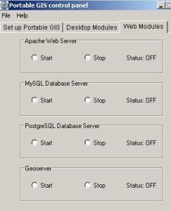 One of the biggest attractions is the server type applications, for the case Apache or geoserver, that only to learn to install them the first time occupy a good time; In this case it is only necessary to press the "start" or "stop" button to stop them.
The OpenLayers, Tilecache, and Featureserver programs run from the index.html file, once the Apache server has been http://localhost).
In the case of QGis, it includes Grass, you just have to select the directory when executing it the first time (.. \ usbgis \ apps \ Quantum GIS \ grass). This will also be necessary if you connect to another computer and the system assigns another name to the drive.
PortableGIS is served under GPL license and works only on Windows operating systems.


Thank you very much, it works very well.
which version is the one that brings gvsig included I download the version v5.2 and v5.6 and it does not bring it. only qgis and I have a problem when doing a filter and it does not allow me to edit the layer, will it be because it is portable?
I have installed portableGIS, but only QGIS has been installed, the other GIS programs have not been installed, someone knows why.
Thank you
I rectify, I found it in http://www.faunalia.com/usbgis
Hi Colleague, it's me again from Chile. One query, do not you know where this link went?
A hug and greetings from Chile!
So no idea, it should work fine.
A couple of queries, the displacement of everything?
Is it a map that is in more than one UTM zone?
If you export the road map to kml and open it with Google Earth, are you displaced?
Hello,
Thank you very much for answering.
In the geoserver in the entity I put in the variable SRS 900913 that is the one that uses google maps, with this my map of roads is visualized well but instead of putting it in Spain it puts it to the right of the map of Spain.How I can solve it ?.
In what format would you have to have the file to be displayed on the map?
Thank you very much.
Andrea
Apparently the problem is, in that your road layer is in UTM and Google Maps requires Geographical coordinates.
Hello,
I'm starting with geoserver and openlayers. I have a layer of roads that I want to go over the map of google maps but the geoserver does not provide the lines well, instead of lines come out as spots. In the console of the tomcat gives the following error:
Possible use of the "Tranverse_Mercator" projection outside its area of validity.
Latitude is outside the allowed limits
Anyone know what it can be ?.
Thank you very much.
Andrea.
Hello,
I'm trying to insert a layer (extension file .shp) with quantum gis to a database of postgres dtaos. When inserting the file gives the following error:
Problems inserting file spatial objects:
C: \ Documents and Settings \ user \ Desktop \ tests \ pc.shp
The database gave an error while executing this SQL:
INSERT INTO “public”..”file_p” VALUES(0,' 110000′, I','0′,'471.649′,NULL,NULL,NULL,'0′,… (cut off the rest of the SQL)
The error was:
ERROR: new row for relation “file_p” violates check constraint “enforce_dims_the_geom”
Can somebody help me?.
Thank you very much.