
Spatial Manager: Manage spatial data efficiently even from AutoCAD
I have taken the time to review this interesting application, which I am sure will interest many users of CAD technologies, who aspire to work with GIS data, such as shp, kml, gpx files, connect to databases or wfs services .
Is Spatial Manager, a development that comes in two versions: One for desktop, which has its own CAD-GIS features, and another as a plugin for AutoCAD, which is available for versions from AutoCAD 2008 to AutoCAD 2015.
We are aware that today there are many tools on the market, both open source and proprietary, so making new solutions requires careful work on the gaps left by large software manufacturers and the common routines of users. After downloading the tool and testing with different data sources, I believe that its capabilities answer questions from geoengineering professionals such as:
Is it possible to connect AutoCAD with PostGIS?
How do I modify a KML file from a CAD?
Can a WFS service be called from AutoCAD?
How to convert Open Street Map data to ESRI Shape file?
1. Spatial Manager for desktop.
The desktop tool does routines for viewing, reprojecting, editing, printing, and exporting spatial data. This does not require AutoCAD, as it runs independently on Windows.
Spatial formats supported
While Spatial Manager for desktop looks simple, its GIS/CAD data management capabilities go beyond my initial expectations: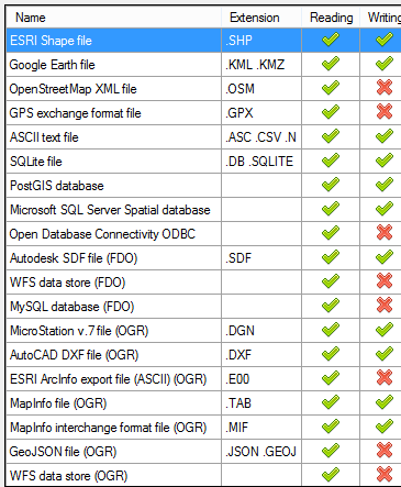
- Read data from nearly 20 spatial sources, as shown in the table to the right.
- You can edit vector and tabular data from Google Earth SHP, KML/KMZ files.
- You can read and edit text files as ASCII text, such is the case and lists of coordinates in CSV format.
- Via OGR you can edit DGN data from Microstation V7, as well as DXF, TAB/MIF from Mapinfo. As an E00 read from ArcInfo, GeoJSON, and WFS.
- As for spatial databases, you can directly edit PostGIS, SQLite, and SQL Server.
- It can read via ODBC (not edit) other database sources.
- Via FDO you can edit AutoDesk SDF data, read Web Feature Services (WFS) and MySQL.
- It can also read GPS exchange standard (GPX) data
Coordinate Transformation
To call a source, only the format must be selected, and the wizard leads to decisions such as destination layer name, data that will be provided as a query, color, transparency, and whether to keep the polygons or generate arc-node type data. Over time you will find very practical features, such as scheduled tasks and drag / drop from Windows Explorer.
It is also possible to indicate the projection and reference system that the initial layer has, and request that it transform it to another; very practical in case we have data from different sources and that we hope to visualize in the same projection. Supports many reference systems, which can be filtered and sorted by name, region (area/country), by code, by type (projected/geographic).
CAD – GIS functions
It really is a powerful tool, because once the data is displayed you can very easily modify the display properties, separate layers by attributes, change the order and best of all: call a background image or maps from Bing, MapQuest, or others.

Some of the functionalities are not seen, unless they are required, since they are contextual. As an example, see that selecting a record activates selection options, such as delete, zoom to data, invert selection, or create a layer with the selected results.

There are some other functionalities that I don't explain in detail in this article, such as printing deployment maps or selected attributes, which is quite intuitive.
Export to other formats
Vector data, once identified in the data sources panel, can be exported to the following 16 formats: SHP, KML, KMZ, ASC, CSV, NEZ, TXT, XYZ, UPT, DB, SQLITE, SDF, DGN, DXF , TAB and MIF.
See that this export would bring commonly used routines, but now not any application does, such as opening Open Street Maps (OSM) data and exporting it to DXF or SHP.
Saving routines as tasks
Spatial Manager is not a complete GIS tool, like other solutions, but a plugin for data management. However, it has features that any GIS user would expect to use for its convenience. An example is the functionality known as Tasks, in which a routine can be saved to be called again at a later time, for example:
I want to save a data layer called parks.shp, as KML format, and that layer is initially in CRS NAD 27 / California Zone I, and I hope it will be transformed to WGS84 which is the one used by Google Earth. Additionally, use the data NAME as the name and PROPERTY as the description, a blue fill color and yellow border, 1 pixel wide and 70% transparency. With altitude hunted on the surface and in a specific Dropbox folder.
When I run it for the first time, it asks me if I want to store it as Task, to run it at any time, even from the command window of the Operating System.
If I save it as Task, when I consult it it will have the following descriptive data:
Click 'Execute' to execute the following options:
Data source:
- File: Shortcuts: \ Sample data \ SHP \ Parks.shp
Data destination:
- File: C: \ Users \ galvarez.PATH-II \ Downloads \ Parks.kml
Options:
- The target table will be overwritten if necessary
Coordinate transformation:
- It will transform the coordinates of the source with the following parameters:
- Source CRS: NAD27 / California zone I
- Target CRS: WGS 84
- Operation: NAD27 to WGS 84 (6)
Saving Routes and Project
Shortcut paths, known as Shortcuts, can be defined similar to what ArcCatalog does, when identifying a data source that will be queried very frequently. The file can also be saved with an .SPM extension, which saves all the configurations just like a QGIS project or the ArcMap MXD would.
Spatial Manager Desktop Licensing and Pricing
It can download trial versions of Spatial Manager. There are three editions of this tool: Basic, Standard and Professional, with scalable functionalities, as shown in the following table:
2. Spatial Manager for AutoCAD.
This plugin is ideal for adding spatial capabilities to basic versions of AutoCAD, although it also works on top of Civil3D, Map3D, and Architecture.
In this case, I have tested it using AutoCAD 2015, and once installed, a tab appears in the Ribbon with some features. Of course, not all of them come from the Desktop version, because AutoCAD has its own commands for this.
In case of creating a data source, all you have to do is right-click on “User data sources"And select"New data source”. Then the font type is chosen, which are the same options as in the desktop version.

We know that some of this can be done from AutoCAD Map and Civil 3D via OGR, however when we review everything that Spatial Manager does, we realize that the creators of this application have thought with dedication about all the features that AutoCAD users they cannot do practically. Aspects such as calling a PostGIS layer, to give an example, or a WFS service published from a GeoServer layer that shows an Oracle Spatial data store.
To see the functionality of Spatial Manager in AutoCAD, we have made this video with examples of our interest.
In the video initially a local shp layer is called, with the country boundary, then one with the municipalities boundary. Subsequently, a connection to WFS services is made and finally a layer of Microstation DGN file plots in arc-node form.
It can be indicated that the points are displayed as AutoCAD blocks, even that different blocks are used based on a characteristic of the data. Also establish if they will come as polylines, 2D polylines or 3D polylines.
Then, if you tell it to import the attributes as embedded XML data, they will be returned as Objects Extended Entity Data (EED). In this part it looks a lot like what Bentley Map does, to import embedded data into the DGN as XFM extensible data.

Spatial Manager Licensing for AutoCAD
There are two versions of Licenses, in this case one called Basic Edition and a second Standard Edition, which are almost the same, according to the following list of features:
General Capabilities
- Import spatial data into AutoCAD drawings
- Coordinate transformation on import
- Embedded data viewer panel (EED / XDATA). This functionality is only in the Standard version.
Import Capabilities
- Objects are imported into a new or existing drawing
- Objects can come to a destination layer based on a data value
- Use of blocks or centroids
- Block insertion based on tabular data
- Polygon fill and transparency
- Polygon centroids if necessary
- Elevation and thickness from tabular data
- Import data from tables as EED. This functionality is only in the Standard version.
Data Sources
- Handling shortcuts
- Access to spatial data (SHP, GPX, KML, OSM, etc.)
- Management of own data sources. This functionality is only in the Standard version.
- Access to spatial databases. This functionality is only in the Standard version.
- Access to other connections (WFS, ODBC, etc.). This functionality is only in the Standard version.
Price of Spatial manager for AutoCAD
The Basic Edition is priced at US$99 and the Standard Edition is US$179
In conclusion
Both tools are interesting solutions. I find Spatial Manager for Desktop very valuable, since the data transformation, editing, export and analysis functions live up to its name. Although as I have mentioned, it is a complementary and intermediate instrument between the routines that are done with a CAD and the exploitation of information that is done from a GIS software.
The second one seems to me that it will grow a little more as it receives more feedback from users; for now it complements what AutoCAD cannot do.
Considering the prices, the investment does not look bad, if we take into account the benefit it can bring.
To know the price list, you can consult this page. http://www.spatialmanager.com/prices/
To learn more about features and news, this is the Spatial Manager Blog or in the wiki


