
Place Bing Map as a background map in Microstation
Microstation in its CONNECT Edition, in its update 7 has activated the possibility of using Bing Map as an image service layer. Although it was possible before, it took a Microsoft Bing update key; But as you may recall, Microsoft is now Bentley's primary partner in the Pavilion Alliance, with which a key is no longer necessary, only having the CONNECT session open.
CONNECT is a service through which you have access to updates, training courses, control of user-managed projects and ticket management. This service exists on the online platform and also in the client version.

As we heard at the Singapore Conference, the technology called ConceptStation in the DgnDB / iModel environment will allow not only this connection to Bing map services, but also very soon MapBox and Here.
Once the CONNECT client session has started, indicating the coordinate system, it is possible to call a background map from the attributes view.

From the Bing data layers, it is possible to have:
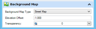 Map of streets: a cartographic type map with roads and place names,
- Aerial - aerial image,
- Hybrid: a combination of aerial image and roads and place names,
There is the option to define elevation for the case of roadway images on the 3D model, as well as to establish percentages of transparency.
Interestingly, the Microstation background map configuration stores it in a buffer associated with the view (View), so that it can be activated in separate windows in a synchronized, independent and even saved way, making previous or next view with the speed of rendering in which Microstation has always been very robust.
For now the tessellation is a bit slow, but it depends on the type of Internet connection, especially when zooming in or out. But once downloaded, it works like a charm.

To call the service from the command line:
Key-In - SET BACKGROUNDMAP NONE | STREET | AERIAL | HYBRID [zOffset, [transparency, [viewNumber]]]


