
3 News and 21 important events in the GEO context - Starting 2019
Bentley, Leica and PlexEarth are among the most interesting novelties starting in February 2019. Additionally, we show we have compiled 21 interesting events that are on the way, in which the entire community of geoengineering professionals can participate. Some of the topics addressed in these events are: BIM, GIS, PDI, Geostatistics, design, CAD and also IoT.
Ask the Expert - MicroStation CONNECT Edition
 This has been launched by Bentley, as a valuable alternative for users who often need advice beyond the technical support offered by manuals or webinars of the applications. This need I remember having raised in one of the events in London, back when in the cadastral system of a Central American country we wanted to migrate from Geographics to BentleyMap a set of developed applications, plus 4500 files in dgn with historical versioning that had to pass to Oracle Spatial .
In short, they are free sessions called “Ask the Expert”, on Tuesdays at 12 noon, US Eastern time and 1 PM London time.
Here you can join, to be aware of the issues that are coming.
As an example, these are the topics that will be taken in the following weeks:
- 12-Feb parameter configuration WorkSpaces and WorkSets in CONNECT Edition applications
- 19-Feb Migration applications developed with VBA, BMR and MDL
- 26-Feb Cloud services for CONNECT Edition applications
Leica Geosystems + SVAB
The giant Leica Geosystems, has been characterized for many years as one of the pillars in the creation, management and monitoring of technologies that are used to date, from the geospatial field, security, defense, engineering to construction. On February 7, it was announced that its partnership with SVAB, a company dedicated to the development of products for excavators -ranging from the control, to the sensors and controls-; It paid off, both have presented one of the solutions for machine control, focused on the productivity of the iXE3 and iGW3. This solution is nothing more than a system based on the recognition of the Quantum SVAB tools.
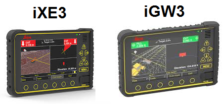 If we remember, the Leica icon iXE3 is a system that allows the control of the machinery in 2D and 3D with high precision, through a control panel can create terrain models, giving flexibility in the field; On the other hand, the iGW3, is a real - time positioner of the shovel - bucket of the excavator, to be able to make immediate modifications and avoid time expenses by verifying the exact leveling of these.
The system presented by Leica + SVAB, is the Tool Recognition, it is totally wireless - it is connected through Bluetooth Low Energy (BLE), and it has the possibility of detecting which is the tool of the machinery with which the processes of excavation, and also identifies which systems or tools are integrated into the machine.
This innovative system is integrated with the previously developed technologies, the iXE3 and the iGW3, which translates into a greater and effective handling of the industrial machine
Some operators change buckets several times a day; With the tool recognition settings, the risk of human error is eliminated. Integration with the machine control solution means the operator only needs to focus on one panel
One of the advantages of this system is the facilitation of processes for machine operators, eliminating the need to change the settings manually. In addition, it prevents any operator (novice or expert) from using the bucket-shovel incorrectly, creating waste of time and repetitions of excavation since the system is communicative - it sends alerts if the operator selects a tool without a tool recognition module - and fully automated. Another advantage is that it recognizes tools such as standard tilt buckets and removable tilt rotators.
The tool recognition system establishes a new standard that takes advantage of the information in which the work tool of the machine is connected.
We expect, from this side, the quality of this product, as they have achieved throughout Leica's trajectory, without neglecting its Co-creator SVAB, who have been leaders in offering products in the area. hydraulics. Sooner rather than later we will see the application of this system and the benefits it brings.
Plexscape + Bird i
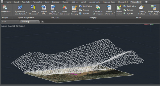 Most know Plexscape for being developers of the so-called PlexEarth, one of the fundamental tools for professionals who use CAD systems in the efficient designs of AEC (Architecture, Engineering and Construction) projects. Plexscape recently made an alliance with TranSoft, and a new partnership with Bird.i never ceases to amaze us; a platform for accessing and observing images from satellites or airborne, which obtains data from some of the greats in the field of imagery such as: AIRBUS, Digital Globe, Bluesky, or planet. Bird.i merges access to images with artificial intelligence processes, to obtain high-quality geospatial data for the AEC market and processes.
The need arises for the integration of the aforementioned, as the answer to all those difficulties that occur, when carrying out any activity that involves images with geoengineering processes; as for example: purchase of high resolution images (high cost), errors in design, delays or processing with free images with limitations of use, low accuracy or reliability.
At Plexscape, we are committed to changing the way engineers work on architecture, engineering, and construction (AEC) projects by bridging the gap between design and the real world. " said. Lambros Kaliakatsos, Founder and CEO of Plexscape.
PlexEarth and Bird.i have created mechanisms so that small, medium or large companies, which are managed in the field of construction, oil, gas, mining, or renewable energies, can make use of satellite images within CAD platforms such as AutoCAD . Timely access to geospatial data allows the CAD user to generate updated, better-founded data and spatial-structural monitoring, quickly and easily.
We firmly believe that our partnership with Bird.i will allow AEC professionals to design with the utmost confidence and take their processes to the next level through instant access to premium content.

How will the process be carried out?
Well, in the first instance Bird.i is working on unlocking the access of high-end images, on the other hand, it is known that PlexEarth, the flagship product of Plexscape, has a broad infrastructure based on the cloud and was popularized as a part of of the tools of Autodesk, this will contribute with the cataloging, distribution and selection of the specific images that the professional requires, so that later it can be used in processes of design and data management, based on AEC.
Events calendar
Here is the list of the aforementioned events, just select the one of your interest and it will take you to the registration page.
Geospatial
24 April - Understand the benefits of cloud mapping. Realizing the Benefits of Mapping in the Cloud
20 February- Creation of a traffic operations panel with ArcGIS. Creating a Traffic Operations Dashboard with ArcGIS
12 February - GIS Workshop: OpenUtilities - February. SIG Workshop: OpenUtilities
12 February- PostGIS popular workflows to improve the resolution of spatial problems. Popular PostGIS Workflows to Improve Spatial Problem-Solving
12 of February- GIS Workshop: Modeling reality for EMEA. SIG Workshop: Reality Modeling for EMEA
13 February- GIS Workshop: OpenRoads - February.
13 February- SIG Workshop: Structural analysis software
27 February- New updates of the geospatial technology competence model and the essential knowledge of GEOINT. New Updates to Geospatial Technology Competency Model & the GEOINT Essential Body of Knowledge
27 of February- Modernization of Grid Grid Modernization
February 28- Effective transit route and high-level planning with TBEST. Effective Transit Route and Stop-Level Planning with TBEST
7 March- View your data in a new dimension using Gis 3d. See your data in a new Dimension By Using 3d Gis
13 March- Use of Earth observations to monitor water budgets for watershed management. Using Earth Observations to Monitor Water Budgets for River Basin Management
16 of April- Data visualization and time series analysis using Surfer Data Visualization and Analysis of Time Series Using Surfer
Engineering
February 12 OpenRoads Designer: adaptation to change
From the 12 of February to the 9 of April- Introduction to the BIM 360 design. Introduction to BIM 360 Design
14 February- News on Civil 3D and Infraworks. What's New in Civil 3D & Infraworks
19 February Tech Talk: Introduction to the structural company
21 February- Tips and tricks to work with demographic data. Tips and Tricks for Working with Demographic Data
27 February - High speed design for high speed bridges: OpenBridge Designer, a Bentley BIM solution. High Speed Design for High Speed Bridges: OpenBridge Designer, at Bentley BIM Solution
5 March- Embedding of location intelligence in web applications that improve the user experience. Embedding Location Intelligence in Web Apps that Enhance User Experience
13 March- Web Seminar: Use of open source GIS to integrate geospatial workflows and CAD - 13 March of 2019. Webinar: Utilizing Open Source GIS to Integrate Geospatial and CAD Workflows - 13th March 2019


