
The application of topological norms in the Geospatial context
One of the 6 2014 Cadastre declarations, set out in 1995, in which many experts from the International Federation of Geometricians put forward what the Cadastre would look like in the 2014 year, was: "Cadastral Cartography will be part of the past. The modeling".
Cartography is a very old discipline, and at all times it has been at the service of initiatives of great importance for the human being, depending on the time: Conquests, Wars, Religion, Research, Tourism, Ecology, etc. Today it is not a different case from other times, although the products of representation are totally different; Before, a map was a true work of art due to the level of detail and the cost of its elaboration. The standards in these times were limited to aspects of a visual nature, such as size of letters, symbology of lines, points, fill, pattern, etc. although the scientific principles remain almost the same in the present time. Technological limitations made it necessary to handle different data models, at different scales.
Today we have databases, computerized and interconnected information systems, so that different versions of reality can be represented in the same data model.
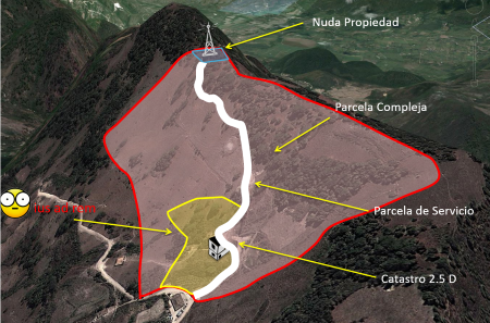
The sample image is just a case of the complexity of our real life, applied to the case of land administration:
- There is an original building.
- At the top has ceded the right to a telephone company to exploit its use for 25 years.
- Additionally, there is a street, which has been built for the company that owns the tower, over which it has not only the right of way but the responsibility of investing 8,000 dollars every year in maintenance.
- The owner's house has been left below the street.
- Additionally, there is an area marked in yellow, the ownership of which is a will written by the late owner. This testament said that the son will be the owner of the property, once he marries and his son is born. If not, the property must become communal property. The son married, but has discovered that he is sterile. The supreme court cannot resolve anything regarding the will to issue a judgment, especially now that his wife is transsexual and cannot have children either ...
It is clear that the last case I have exaggerated only to remember the wide range of possibilities. The arrival of the computer age certainly marks a milestone in information management, not only because it is necessary to create systems for human interaction, but also because the interest in sharing information in international contexts is globalized. The case of ISO 19152. is a clear example of how all these possibilities in land management have been modeled, with classes, subclasses and attributes defined for each possible case.
More than giving complexity to the subject, what the LADM standard (ISO 19152) seeks is to help the institution in charge of managing land in a country to fulfill its generic role, regardless of its size, registry-Cadastre link, etc. And that generic role will always be:
- Maintain the relationship of property rights.
- Provide information to the public about this registry.
So, modeling is a trend from mathematical application to the geospatial era.

1. The standard is an obligation of semantic balance.
The inventiveness of the human being is aggressive, especially when the marketing of the results is highly competitive, every day we are surprised by new applications based on the management of spatial topologies. The need for the standard arises just to create a balance between the offer of the benefits of technology in terms of spatial databases, GIS, Internet, free code, high performance equipment and, on the other hand the demand of people, public and private institutions to interact with the information efficiently. The existence of these standards makes the recognition of rules and norms official with which the objects of reality can be modeled under the same semantic language. The accepted international validity of an international standardization organization (ISO) allows today, -in the case of geography- that the flow involving the acquisition, processing, analysis, presentation and transfer of spatial data between different users, systems and locations is facilitated. As a result, companies that once monopolized their position with products or services now seek to make compliance with standards visible.
2. The role of the OGC in geospatial standards.
In the case of geospatial standards, most existing ISO standards are developed by the Open Geospatial Consortium OGC -before Open GIS Consortium- who participates in the Technical Committee (TC / 211) responsible for geographic and geomatic information issues, usually in the 19000 range. 481 entities currently participate in the OGC, including companies, institutions and public entities related to disciplines in the geospatial area. Thanks to this instance, interoperability in the current use of technologies in the geographic field has been greatly enhanced. It is also necessary to recognize that part of the merit of the OGC is due to the current trend for democratization of knowledge promoted by open source. Although the OGC has had that name since 1994, its antecedent is due to the sustainability effort of the oldest open source Geographic Information System: GRASS, which has existed since the XNUMXs. It is also interesting to see that there is a irreversible trend of public, regional and international institutions to bet on the sustainability and application of standards. The case of the Land Administration is evidenced by initiatives such as: INSPIRE, which adopts ISO 19152 as a specialization in land management, LANDxml.org is another case, the European Land Information Service EULIS and FIG itself.
3. The challenges of new professionals in the geospatial area.
 The current importance of standards forces new professionals linked to geospatial issues, not only to know but to deepen. Beyond capturing, analyzing, managing or exchanging data, they must know how to read models, interpret rules, spatial schemas and, above all, the languages in which they are documented. The challenge is not easy. Traditional roles have been separated between those who capture (surveyors, surveyors), those who analyze (geographers, engineers, geologists), those who produce final material (cartographers, draftsmen) and those who make data management systems (computer science) . Now all disciplines are combined in the use of technologies, which requires a unified modeling language, this is the UML.
But: How many standards should we know?
We are aware that there is a risk of getting lost within so many documents, norms, rules and protocols. Beyond using the standards, which we do every time we integrate a WMS layer, WFS, it is convenient for professionals to delve into this context gradually.
- In the first instance, it is a good idea to master the main aspects of the UML language. This can be done next to knowing the CSL (Conceptual Schema Language), quite simple to understand since its scope is schematic at the level of abstraction of the real world. We have been doing it since high school, when we made concept maps or mind maps; that developed our capacity for understanding, synthesis, abstraction, and the CSL is nothing more than a standard applied to that field.
- Then it will be convenient for you to know the main regulations, especially those related to your role schema within the geographic data production cycle. To mention a few, Spatial (ISO 19107), Temporal (ISO 19108), Quality (ISO 19115), Gazetteer (ISO 19112) and Metadata Schema (ISO 19115).
- In the third instance, it is also useful to understand the architecture tendencies of computer systems, especially those oriented to services (SOA), where this design process can be observed from the general conceptual to the methodological in the level of details and data.
In conclusion, the incorporation of topological norms in the geospatial context are aspects that, although they make complex the role of the new professional of the earth sciences, are the cause of the sustainable rise of the application of the geographic information to many daily disciplines. Learning to understand models will only enhance the opportunities of professionals who expect to be competitive in the new geographic context scenario.


