
Google Earth Applications for Epanet
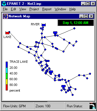
Epanet is a very useful application for hydraulic analysis, in which you can configure a pipe network and learn network analysis that manually require many calculations, as well as make simulations and analysis of water quality based on discharge distances (and of any fluid). The best thing about this system is that it has mapping support, although initially it was built in English by the US Environmental Protection Agency, hence its name EPA, later the Polytechnic University of Valencia promoted the work for the use of Spanish speakers.
Epanet is a free licensing software, the format of files generated with Epanet has the .net extension and also .inp
In this review I am presenting some applications that have been built for Epanet:
1. Export from Epanet to ArcView
With This application you can convert an Epanet file to a shape file, requires the free librarian Epanet2.dll.
2 Export from Epanet to Google Earth
With This application Epanet files are exported at kml / kmz, you can choose to send only the network or also a generated simulation. At the time a file is exported, the system allows choosing the original projection and datum since Google Earth only allows geographical coordinates.
3. Import data from ArcView to Epanet
This application pemite to convert .nip files from a shape file, you can use point files, or also lines with the option of placing nodes in each vertex or intersection.
4. Import data from Excel to Epanet
This application created with Visual Basic subroutines allows you to import Excel points, containing an identifier, x coordinate, y coordinate, z coordinate and converts it to a nodes file (.inp extension)
5 Import points from the GPS to Epanet.
With This application you can create networks of nodes, tanks or reservoirs directly from the GPS through .gpx files
 6. Create Epanet files directly on Google maps
This application It works online, and allows directly on Google maps to create Epanet files, choosing if nodes, tanks or reservoirs are being created. The best thing about it is that you can place the pungos using lat / long or UTM coordinates.
7. Rotate files in Epanet
With This application you can rotate a data set, just by specifying the rotation node and angle. The system recalculates the extent
8. Sensitivity analysis in hydraulic networks
This application is quite interesting because assumptions can be made as to what would happen if all these users started to consume more water? o What would happen if the pipe diameter were increased at this point?
There are also other applications like Export from Epanet to Excel and graphical analysis multi-species.
One of the interesting aspects of these applications is that they are free, created by a student of the University of Arizona, in this link can be view all the free applications for CAD and GIS.


svp j'aimerais savoir comment quitter d'excel à Epanet.je n'arrive pas à trouver l'extension inp dans les types de fichier that propose Excel
Interesting the following link on epanet and swmm in arcgis 10
http://www.youtube.com/watch?v=3Rx9VqSwkj4&feature=BFa&list=LL9kSacPrkBhix94FheTG9Rg
http://www.youtube.com/watch?v=2Xi0jy0u8iY&feature=BFa&list=LL9kSacPrkBhix94FheTG9Rg
These applications are not geofumadas, they were made by Zonums, and they had expiration date. There's nothing we can help you with.
Gentlemen creators of this page I am very impressed with the applications you have for epanet but I downloaded the one to import data from excell to epanet and it tells me that the beta license has expired ... maybe you could help me with this regards.
Lords responsible for this page, I think we should be objective and not lose sight of the purpose of the comments, I think we should analyze, greetings!
Hey Sara21, what an emotional mess you get to see with that comment about Rufino, you must have practical sense and locate yourself in real life, in the end you did not help him but if you tried to interfere in third-level issues that are not relevant, greetings and Improve your participation!
Rufino, first you have to ………
Comment edited by moderator of the blog.
Hi I am responsible for SIAPASO in ocotlan jal, in the 2007 contract was a diagnosis of sectorization in the header, epanet was used as help only that I have not used it because I do not understand it and I would like to help me to handle it to apply it in my municipality .
thank you I just bought this machine and still I do not know how to put the arroba an apology
thanks for everything
I hope you will do me the favor and help me learn how to best manage the EPANET because I really need it