Designers´s Companion, a great complement for Civil 3D
This is one of several solutions offered by Eagle Point, the same company that at the beginning of the nineties impressed us with everything that AutoCAD did not do.  After a slight lapse, in which he wanted to devote to doing almost everything, the company returns to its initial goal, by then AutoDesk already had a good time with applications for Engineering, Architecture and Construction, which now stand out Revit and Civil 3D
Designer's Companion facilitates the execution of tasks, which can be done with AutoDesk Civil 3D, but automated to work in fewer steps, let's see at least one example:

We already have a surface, with curves of level and what we want is:
- Project a road with a right-of-way of 8 meters and radius of curvature 65 meters.
- Design lots on the right with a criterion of 400 square meters.
- Design lots on the left with a criterion of 600 square meters.
- As the street is dead end, in the end we want to place a return, those known as Cul-de-sac, Very common to avoid traffic and noise in residential areas.
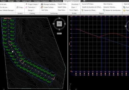
Well, just go to the tab Designer's Companion, Select option Draw Street, fill the parameters and this will raise the panel of Civil 3D to create alignments.
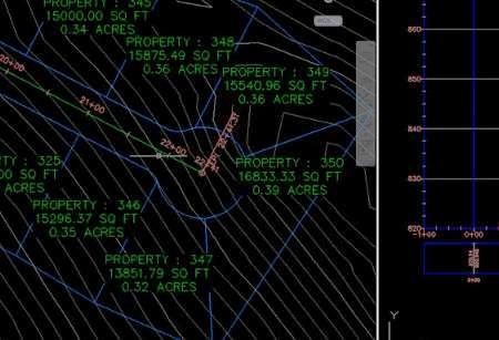
We draw the axis of the street and voila, we will have the subdivision in plan, with the plots adapted to the condition and its centroid linked to its area and lot number, maintaining the area that we established. Also the profile in another view, with the stations and elevations equivalent to the plant.
 Now, to make the end of the dead end, we must select Place cul-de-sac, Then choose whether it goes to the center, left or right, the radius of curvature and the area criterion for the surrounding plots.

And ready, there we have it.

Undoubtedly, all this can be done with AutoDesk Civil 3D, but if we compare the number of steps to do the alignment, then create the profile, do the plots and the cul-de-sac. The savings are definitely significant.
Beyond that, if we want to make a change. For example, moving the axis of the street at one point, everything is updated on the fly, keeping the criteria.
Desinger's Companion. Simplify design work with AutoCAD Civil 3D in both scribing and reporting in the creation of surfaces, alignments, streets, cross sections, parcels, cut / fill volumes and plumbing systems.
In short, Designer's Companion are tasks that we do with Civil 3D, simplified to common routines of designers.
Although I have summarized the application in dynamic plots associated with a street axis, there are other functionalities in other topics, such as placing in a profile the entrance of pipes even if a complete network is not designed, dynamic design of parking lots in a Urbanization, create an 3D polyline associated with a surface from slope projections, etc.
Because it is built on the new interface, we assume that it will not have compatibility problems with the 2012 version of Civil 3D that we will soon see in this year. In this video you can see the intuitiveness of the tool, and in a small window the same, but only with Civil 3D.
- Go to Designers Companion
- Ir a Eagle Point
- Go to Civil 3D


