Euroatlas: old maps in shp format
It happens to map fans, who at the supermarket buy a magazine just to bring a large fold-out map or an atlas that adds to the collection of what we already have. Encyclopedias have done their best to show interactive maps in Flash or developments that simulate the operation of a geographic information system, but in vector format we only saw for graphic design programs.
What Euroatlas has done is on the picket line. Until a while ago it was dedicated to publishing very well elaborated printed atlases, now they are promoting maps that are supported in vector format with an interesting campaign:
"make your own historical atlas with historical GIS maps"

Let us give him the eye we have left before going to sleep:
GIS Maps. If it's about historical atlas, old and referencia For travelers, Euroatlas has enough, but what strikes me is that vector layers can be obtained in shape files for use with GIS programs. They, as they are not chalk, only mention ArcGIS, Open Jump and Map Windows, but obviously this archaic format is now recognized by almost any CAD and GIS program. They come:
- a pdf with the description of the layers
- styles in sld
- a prj that includes the layers and projection
- and the traditional shp, dbf and shx.
 Among the maps in GIS condition there are (for now) historical maps of each of the 20 centuries that precede us with prices from 30 Euros. Of course, you have to carefully review the license of use for copyright purposes in case you want to publish new content.
In the case of Corel (cdr) or Illustrator (ai) formats, they already come with layers created. Here is a complete map of Europe 2009 and the Ancient Rome
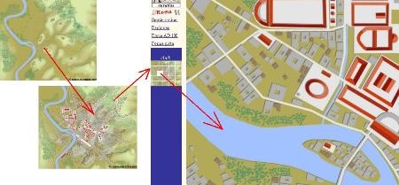
Web Deployment. One of the interesting aspects is that several maps can be viewed online, to motivate the purchase. See the case of the Ancient Rome, the seven original hills (Septimontium), Rome of the first century and with a mosaic that makes it easy to see the detail ... succulent! and in Corel Draw.
Very interesting, for educational and travel purposes it looks very useful. I recommend it.
Website: Euroatlas