GeoConverter integrates into CONDOR
GeoConverter, Geobide's geographic data converter, allows you to easily execute massive data conversions. The normal working process of this application works sequentially, each input file is converted and does not follow the next until this individual task ends.

This mode of execution queues all the work (N individual tasks) and the total time of the process will be proportional to the number of data converted and the power of the only machine that executes it.
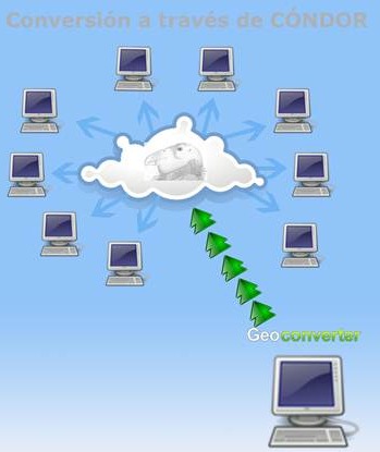
CONDOR is a free software that allows the user to define a set of machines to execute tasks in a distributed and concurrent manner. The user with its use manages to optimize the speed of execution of a process taking full advantage of the hardware resources of its organization.
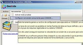
With this purpose, GeoConverter it adds a new functionality so that it can be integrated into CONDOR, allowing to generate a special configuration file that can later be executed within this environment with the command 'condor_submit'.

When the user submits this work to CONDOR, it will distribute it among the registered machine farm according to its power and idleness. That is when, to execute the conversion process, all the available power in your organization is effectively used.
The configuration file commented above contains all the necessary tasks to perform the conversion that the user defined in the normal way with the application and is created from the new menu option "Tools" of GeoConverter.
 With GeoConverter, and through CONDOR, we could for example perform massive mapping conversions in a much faster way because the total time will be reduced proportionally to the number of available machines. Think about the daily transformation of thousands of files, replicas to other formats,
Interesting alternative for an organization to have several idle machines at "night" schedules.
http://www.geobide.es/productos/geoconverter.aspx


