Geoinformatics March, continues the Open GIS
 This month's edition of Geoinformatics has already come out, which on its cover shows a Digital Globe satellite image of southern Iran as a prelude to the article dedicated to the services of the German company GeoServe. Mostly it is giving continuity to Previously played themes and we are pleased that the tendency at least this year to show open source technologies applied to GIS is very clear; Last month they talked about gvSIG and now they focus on other tools like Quantum GIS and Calypso.
Articles
![]() The high precisions in the image capture of the project FLI-Map 400.
The high precisions in the image capture of the project FLI-Map 400.
A recommended reading, showing how far you can reach (or smoking) by using point cloud capture technology known as LiDAR.
![]() The Reykjafik Project,
The Reykjafik Project,
Applying the gps to combat Graffiti
![]() The Calypso project
The Calypso project
A broad article that shows us the benefits of this open source software of German origin applied to hydrology.
![]() The Open GeoStack
The Open GeoStack
Interesting position by Sebastian Benthall that talks about the sum of the parts in open source GIS applied to GIS technologies and how good levels can be achieved using applications such as PostGIs, GeoGerver, GeoWebCache and OpenLayers.
![]() Quantum GIS 1.0
Quantum GIS 1.0
In the style of the previous article of gvSIG, history, which is and does not make this tool that to date is seen by many as the most evolved open source in this matter.
 Additionally there are other topics such as:
- Business Mashups
- The glory of GLONASS, GNSS update
- A profile of ScanEx Company
Software Reviews
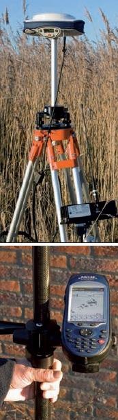
Continuing with the exploration of high-performance equipment, they review the Magellan GPS ProMark 500 GPS capture equipment, it is necessary to read considering that the approach of the somewhat reckless article is called "Back to the future"
Interviews
![]() What is Mapinfo?
What is Mapinfo?
This is an interview with people from Pitney Bowes who talk about the new software and the new division that is being considered after the definitive acquisition.
![]() There is also interesting material regarding off-road machines known as Toughbooks.
There is also interesting material regarding off-road machines known as Toughbooks.
Other non-negligible interviews:
Columns
As always, James Fee writes something short but deep, in this case about taking the spatial analysis to the end user's desk.
In conclusion, a high level reading as expected from Geoinformatics, here is the online version that can be converted to pdf and downloaded locally.