GIS Learning CD, great resource for teaching
Of the best tools I've seen, which can be very practical when teaching in the area of geographic information.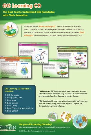
This is the GIS Learning CD, a product of the construction company of the SuperGeo line, which, beyond being a product for instructors, can play an important role in self-taught training.
The announcement came out in the new edition of Geoinformatics, I think it is ideal for programmers that you hire, who may be experts in Java, .NET or PHP, but when doing geospatial development they need training in GIS. Another ideal use is for external consultancies that you hire for tasks such as preparation of training plans, systematization of experiences, editorial review, or similar whose specialties are necessary but require knowing the space world without becoming operators.
The first two chapters gather very rich theoretical material, including GIS concepts, the origin of their development in the United States and Canada, the elements of a GIS, and their application in the management of both natural resources and planning. The characteristics of data models, coordinate systems, projections, scales, topologies and spatial relationships are also discussed.
 In the following chapters, progress is gradually made from information entry, display, consultation, to the processing and publication of results. This is the chapter index:
- Chapter 1. GIS Concepts
- Chapter 2. Geographical data
- Chapter 3. Data entry
- Chapter 4. Data display
- Chapter 5. Data query
- Chapter 6. Processing and Analysis
- Chapter 7. Publication of data
The didactic quality of the material is very good, built in Flash, with very good graphics and an impeccable behavioral thread. It is definitely a great reference for training, in the company of Google Earth, for SuperGeo sure that it is an instrument that will promote its line of products, which although has an interesting demand in the Far East, is little known in our environment.
A regret that for now is only in English, I know that at this point it is a challenge overcome in many spheres, but in the classrooms the reality is different. The disc costs almost $ 50, it works in Windows and Mac environments, it can be purchased with Paypal.
In conclusion, a good toy to learn, teach and put on the wish list.