
Google Maps, with contour lines
Google Maps added the highlight option to the map display, which includes contour lines from a certain zoom level.
This is activated in the left panel “Relief” and in the floating button you can activate or deactivate the view of curves.

The source of this contour line that Google has integrated is the digital terrain model initially developed by NASA and continued by the USGS, which is known as SRTM-90m. This functionality is visual in Google Maps, in Google Earth at the digital model level. The horizontal resolution is 90 meters (it varies with latitude) and based on this curve the rest was interpolated (It is assumed that in the United States it goes through 30 meters but it is useless to us). The vertical error is estimated to be 16 meters.
The download of this contour can be done from AutoCAD, obtaining points from a grid and generating a terrain model with its curves.
Step 1. Display the area where we want to obtain the Google Earth digital model.
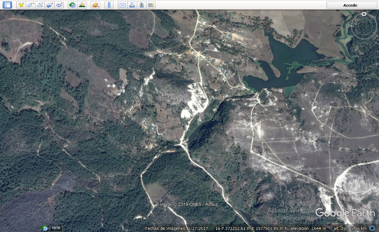
Step 2. Import the digital model.
Using AutoCAD, having the Plex.Earth Add-ins installed. In principle, you have to start the session.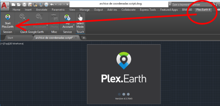
Then we select in the Terrain tab, the option «By GE View», it will ask us to confirm that 1,304 points will be imported; then it will ask us to confirm if we want the contour lines to be created. And ready; Google Earth contour lines in AutoCAD.

Step 3. Export to Google Earth
Having selected the object, we choose the KML Export option, then we indicate that the model is adjusted to the terrain and finally that it opens in Google Earth.

And right there we have the result.

De here you can download the kmz file that we have used in this example.
From here you can download the Plex.Earth plugin for AutoCAD.


야이개좆병신 호로새끼야
등고선 나온 지도를 켜라고 했더니
지도는 없고 씨발 쓸데없는 사진 쳐올려놓고 좆같은 소리만 싸놯어?
계속 개발 한 디지털 지형 모델입니다.
이런 개 좆병신 지체장애 같은 소리나 쳐하고 자빠졌고
지도를내놓으라고 지도를!
양키새끼들이 번역해놔서 한심한 문장이나 쳐 올려놓고
병신같은 새끼들
How otherrò imagini him?
Good…. I would like to know if the "topographic" base used by google earth to show the 3D views and make the terrain profiles is the SRTM 90m model or does it use photogrammetric techniques to make the 3D model???
Sou engenheiro eletricista e faço inventários de rios e bacias and basic projects of hydrological power plants. Gostaria of knowing more about these placements of curves of maps in maps. It would be a nao na roda.
There are different programs to download it. ArcGIS has an extension, as you can do with AutoCAD using Plex.earth
The digital model is the world SRTM. The usefulness of these curves and elevations can be used for studies of large areas, as it is rather simplified. It does not validate against local survey studies. The imprecision in elevations can walk through a range of +/- 20 meters.
Congratulations on the excellent work presented:
I have a query:
The level curves every meter that can be obtained from Google Eearth, with some software such as autocad 3d, what is your level of accuracy? What is your source scale?
The above is necessary because I need to refer to a scale.
regards
These contour lines can be loaded into the GPS maps and followed in the terrain to relieve them ??? Thank you
I would like to know the indications of how to put contours in different places
I would like to know how to see the level contours of the colon area in the department of Lavalleja Uruguay
Good morning, I would like to know how I can get the cartography of the territory of Jalapa Guatemala
Hi, how can I add this leveling service? And higher resolution on satellite photos. Thank you
I find it very interesting the work developed by you, if possible inform me about the release of the same as I am an agronomist and perform technical assistance to farmers in the area where he works in the department of Jalapa, Guatemala
In advance thank you very much.