
GvSIG: 21 CAD tools
A frequent weakness in GIS specialty programs is their limitation in constructing data with the ease offered by CAD-oriented tools. Little by little the gap is narrowing, although it is questionable whether it has been the GIS that has improved its construction capabilities or the CAD that has implemented geospatial variants such as Bentley Map and AutoCAD Map.
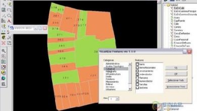
gvSIG 1.9 has made almost literal copies of the most used AutoCAD tools, even in the order that the text line is executed in at least 21 commands. The Marked in red Are news of the Stable 1.9 version, They have not included those that this version maintains in the edition bar, that seem to be of selection.
|
|
It can be considered a significant contribution of gvSIG to have integrated this series of tools, with the AutoCAD work logic. In practice, I have seen technicians build with this tool, although many of them for massive cadastral surveys prefer to work with a CAD tool, create a polygon and then bring them to gvSIG; most of them tell me that it is because on Java the work is always slow.
On the other hand, for cadastral maintenance, once topologies have been uploaded to PostGis, it makes no sense to extract the data and edit it in a CAD tool; and then these tools become useful. Although for large amounts of data, it always affects the consumption of Java resources.


Specialists claim that loans help people to live their own way, because they feel free to buy necessary stuff. Moreover, a lot of banks give student loan for all people.
Bravo !!!, if it works. This is perfect. . . or almost perfect, there is a problem there, it is with an .ecw, when activating the enhancement (RASTER PROPERTIES–> ENHANCEMENT–> ACTIVATE), the program starts the calculations, but stays in the process, it never seems to finish.
On the other hand, I can't find the option "convert polygons to points", does anyone know where they are?
Go, it seems that you have to go more often around this page, thanks to Diego and gvSIG3D for the data, I'll verify and then comment.
Greetings.
Hello,
I pass a link regarding the bug that is being commented on in windows 7 and gvsig when trying to access a raster file [1]. The new build of gvSIG 3D overwrites the libraries that were giving problems in win 7 and win Vista. The development is still in the testing phase, so the feedback from the community is very important.
A greeting.
[1].
As this update works on win7
https://gvsig.org/web/projects/gvsig-desktop/devel/gvsig-3d/product
regards
Editor (at) geofumadas (dot) com
Mmm !, well I did not expect such an awkward response from an expert on this, anyway, I still need your help, could you support me? Is about supervised and unsupervised sextant classification. Is there a way to contact you?
Well, a shame. Good luck in what you will do, surely you have resolved the way to solve the problem.
g!: It's useless, I installed the version of SEXTANTE that you mentioned here, but you can't know if it works or not, since when you try to load any raster the “STABLE” gvsig 1.9 simply crashes; closes and notifies you of an error. It is unfortunate that they add more and more functions to the program, but the ones that were good stop working. . .
I have not tried the version of gvsig 1.9 in windows xp or vista, but with win 7, it simply does not give one. WHAT A PITY!
A thousand thanks g !, I now release it and prove it. The problem that you commented that happened to you is not my case, with everything, thanks for orienting me.
The version of SEXTANTE should be downloaded here
https://gvsig.org/web/projects/gvsig-desktop/devel
Is the 0.3.0 build 1232 version.
I had two problems at the beginning:
The first is that I had downloaded SEXTANTE from the OSOR Forge repository and the other was because I had not uninstalled the Alpha version of gvSIG 1.9 and when it was launched it was raised again, I do not know if that will be your problem.
I agree with “ERROR”, if you install SEXTANTE, the “stable” gvsig 1.9 simply crashes. I also have WIN 7
** g! Is there a version of SEXTANTE that pulls with gvsig stable 1.9, you could guide me what is ?.
By the way, several of the news that announce in this version (stable 1.9), I do not appear anywhere.
Well, I'm up to the gvsig cap. I fail when I enter raster in gvsig 1.9 stop stopping new things and dedicate themselves to stability !!!!
You must download the version of SEXTANTE that notified the community. Should not fail
A free software program that handles cad. Very interesting. I wish someone could work on a CAD-oriented tool for architects.
Greetings.
GVSIG + SEXTANTE DOES NOT START IN WINDOWS 7. EXCEEDS AN ERROR MESSAGE.