
Is Java Worth Learning?
Beyond OpenOffice, Vuze, Woopra, or the applets that are deployed in some web pages, is very positioned in mobile systems, TV, GPS, ATMs, business programs and many of the pages that we surf daily are running on Java.
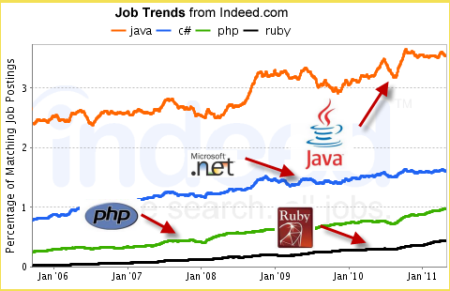
The following graph shows how Java technology has a sustainably marked domain from 2006 to 2011 compared to C # .net, php and Ruby, possibly derived from the job offers.
In the case of the geospatial environment, C ++ and Java are the two great worlds in which Open Source applications are built; The following table summarizes something, because of the topic of the post I focus on expanding on Java applications but at a glance (which it is not), from the Java side it outperforms C ++ in an 15 to 10 relationship.
|
GIS Applications in C ++ |
GIS Applications in Java |
|
At the desktop level
|
|
|
At the server level
|
|
|
At the library level
|
|
 Of the previous ones, at least 5 of those developed in Java appear as projects of the foundation OSGeo, some in incubation, in search of sustainability and complementarity.
It would be interesting to have a round table of programming experts to talk about why they prefer or hate Java, it would possibly be discussed whether or not Pointers make the process simple or not, if the multithreading capacity would have an advantage over other languages if there is no virtual machine, if security is relative ; but on one thing they would all agree:
The fact of being cross-platform, since the applications can run on Windows, Linux, Solaris and Mac (ignoring the recent stubbornness of Steve Jobs). This makes it attractive for applications with a global scope, where users will use different operating systems and browsers, solving almost everything with the famous Virtual Machine that apart from performing multithreaded tasks, solves the portability problem and provides a secure filtering between the client and server.
Also the fact of being Open Source is an aspect to be valued, although Oracle acquired SUN (Java developer), and that some doubts of what can happen in the long term with MySQL (Of GPL license), almost nobody questions the future Of the Java language.
Possibly what the Green Teen started as a failed project to run on televisions and VHS no longer resembles what Java has achieved in positioning, although it does in objectives. To date, there are 3 Java applications:

J2SE (Standar Edition), which is usually used for the construction of distributed applications and applests.
J2EE (Enterprise Edition), usually for multi-tier enterprise tools, remote support services and e-commerce.
J2ME (Micro Edition), with which applications for mobile phones, GPS and digital TV boxes are built.
Learn21 y Globalmentoring Are examples of virtual classrooms where you can learn Java.
So returning to the initial question, if Java is worth learning ...


