
Manifold; Topology and modular structure
I get a request from someone who studies geomatics in Argentina the UTEM of Chile and a professor has delegated a task on Manifold; so I take the opportunity to post about it.
1 Does Manifold support topology?
![]() Yes, to do this you must activate the shared edit option "edit / shared edit"
Yes, to do this you must activate the shared edit option "edit / shared edit"
In this way, the vector content that shares nodes within the precision can associate their neighborhood. Applies both for reprojection and for editing objects manually.
To define the precision, right click on the layer, choose properties and there you can specify the precision conditions that apply to both snap and spatial analysis, topological cleaning and "shared edit".

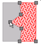

In the example I am showing, if I have these objects, even if they are independent, when moving a node, all the points that converge and that are within the precision chosen for this layer, will move.
 If the shared edition had not been active, this would have been the result:
It is the same for polygons, points and chains of lines; By the way Manifold supports a layer having these three types of objects without requiring them to be separated by exclusive layers.
It is also interesting to understand that the figures can be in different layers, as long as they are displayed on a map; for that matter, you could have a layer with boundaries of plots, in the form of lines while another layer has the polygons. Even at the ends there could be nodes in the form of points ... I know, it is a madness that does not exist in a cadastre but usually happens in water systems where there are valves and wells. The editing of a node modifies the different objects that coincide at this point, as long as they are active within the same view (map).
This was the biggest weakness of the 3x versions of ArcView; GvSIG supports topological control, and Bentley has implemented it in an application for cadastre called "Bentley Cadaster"
2. What is the modular structure of Manifold?
I will only include the price of the version of 32 Bits, to give an idea of how prices behave as it climbs.
A) Personal Manifold, is the basic version. $245
B) Professional Manifold, in addition to the Personal version, includes IMS functionalities. $295, the runtime license of this version is worth $ 100
C) Manifold EnterpriseIt also includes native access to DBMS databases, multi-user editing can also be done to IBM DB / 2, Oracle, SQL Server 2005, SQL Server 2008 ("Katmai"), PostgreSQL / PostGIS, ESRI SDE or personal version databases … Among other things it includes editing of files in .e00 format $395
d) Manifold Database Administration Edition, this version includes more data management features for companies that have a lot of data and users; includes support for IBM DB / 2, Oracle, SQL Server 2005, SQL Server 2008 and PostgreSQL / PostGIS, including batch export to Oracle. $795
There are three extensions, which can be purchased separately or in an option pack of $225:
- Business Tools, includes several tools for spatial management, including Topology Factory, conversion of raster data to vector (as well as Arcscan) and topological cleaning) $95
- Geocoding Tools (tools for geocoding) $50
- Surface Tools (tools for surface handling, profiles and 3D animation) $145
E) Universal Manifold, is the Enterprise version plus the three extensions indicated above $575, the runtime version of this version is worth $ 225
F) Manifold Ultimate, is the version of Database Administration plus the three extensions $845
... a necessary clarification; to move from one version to another, only functionality activation keys are purchased, it means that a version of Manifold includes everything, only activations are purchased according to need.
3 Manifold GIS data model?
 Lightning, this question is more complicated and I don't find much on the Manifold website.
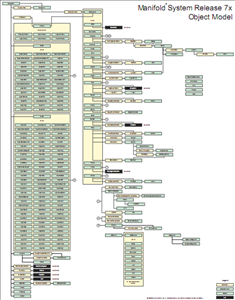
Here There is a link to the object model, I do not know if there is something else and I do not feel in a position to answer this question either ... but here there may be something else.


LOL. Of course it means it was good, my friend! In my replana, it means that you have given him a good piece of information that maybe needed for a task or confusion at concept level that has been COMPLETELY clarified.
Greetings from Peru
Nancy
That "you went too far" I hope it means that it was good
Thank you so much, you really do pass me