What happened to the Top40 Geospatial on Twitter
Six months ago we did a review of almost forty twitter accounts, within a list that we call Top40. Today we make an update on this list, to see what happened between May 22 and the end of December 22, 2014. Of all of them, 11 are in English, two in Portuguese and the rest in Spanish.
The top 10 Geospatial.
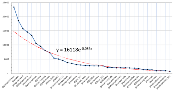
From a total of almost 40 accounts, applying an exponential graph, you can see that the intersection has gone up from 14,000 to 16,000.
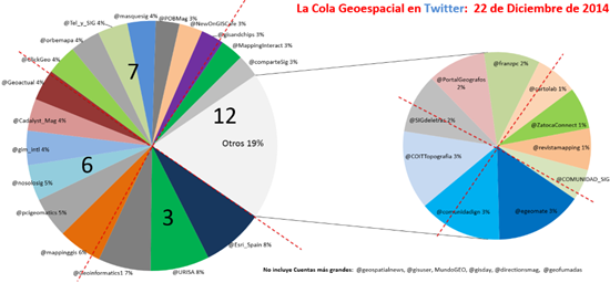
The most interesting change in this 10 top is shown in the following graph, in which the 75% is composed of six accounts, leaving three with the remaining 25%, among which are @geofumadas and @directionsmag that are right in the trend line of the exponential curve.
New chart to 2014 December:
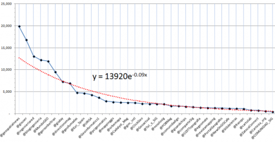
This was the previous graph, where you can see that here only 8 accounts appeared; now they are 9.
3 of these are of Anglo-Saxon origin (marked in red) while one of Portuguese origin (marked in green), then there are three of Hispanic origin, as we explained before, Network Engineering and BlogIngeniería really are not specifically geospatial segment, but are a benchmark of accounts that can grow competitively.
Account May 2014 - December 2014
1. @geospatialnews 19,914 - 23,375
2. @gisuser 16,845 - 18,612
3. @ingenieriared 13,066 - 15,748
4. @blogingenieria 12,241 - 14,593
5. @MundoGEO 11,958 - 13,420
6. @gersonbeltran 9,519 - 10,520
7. @gisday 7,261 - 9,527
The 2 are exactly in the trend, equally separated from the rest of the queue:
8. @directionsmag 6,919 - 8,061
9. @geofumadas 4,750 - 7,300
The rest of the Geospatial Accounts Queue
By leaving the graph separating the first 8 accounts, we have a new graph in which four groups can be distinguished, starting precisely from the Esri_Spain account. The intersect went up 5,200.
The next is the previous chart.
If the same graphic, in a distributive way, we see a more representative view of what is in this collection of 27 accounts, in segments of 25% each one we call Q1, Q2, Q3 and Q4:
The next is the previous chart
Q1: 3 accounts
This segment maintains the same three accounts. These represent 25% of accumulated followers, being Esri Spain is the only software account that I am including, as it is an interesting reference in the geospatial sector.
The change in this segment is the entry of @geoinformatics after the jump from @geofumadas to top10, whereupon @geoinformatics1 enters this list.
Account May 2014 - December 2014
10. @Esri_Spain 4,668 - 5,324
11. @URISA 4,299 - 5,055
12. @Geoinformatics1 3,656 - 4,491
Q2: 6 Accounts
This segment previously had 5 accounts; now there are 6, three of which are in English. We see interesting movements, especially @mappinggis that takes the first place, and the cases of @nosolosig that jumps from position 21 to 15, @gim_intl and @Geoactual. These three were before in Q3.
Account May 2014 - December 2014
13. @mappinggis 2,668 - 3,760
14. @pcigeomatics 2,840 - 3,496
15. @nosolosig 2,184 - 3,071
16. @gim_intl 2,487 - 2,954
17. @Cadalyst_Mag 2,519 - 2,746
18. @Geoactual 2,229 - 2,692
As we had said, the little activity of @orbemapa made him fall to Q3.
Q3: 7 Accounts
In this segment there are still 7 accounts, although with several movements: @NewOnGISCafe and @gisandchips go up from Q4 to Q3. @comunidadign falls to Q4.
Account May 2014 - December 2014
19. @ClickGeo 2,239 - 2,606
20. @orbemapa 2,541 - 2,580
21. @Tel_y_SIG 2,209 - 2,576
22. @masquesig 1,511 - 2,425
22. @POBMag 1,754 - 2,025
23. @NewOnGISCafe 1,187 - 1,998
24. @gisandchips 1,643 - 1,982
Q4: 13 Accounts
This list could be endless, with accounts ranging from 500 followers to 1,700. We are only adding the MappingInteract account, since we had a confusion with your account in Spanish @revistamapping; the rest are the same as above. Of all these, only one is in English. There is also one in Catalan.
25. @MappingInteract 1,277 - 1,967
26. @comparteSig 1,520 - 1,956
27. @geoinquiets - 1,920
28. @egeomate 1,339 - 1,908
29. @comunidadign 1,731 - 1,418
30. @COITTopography 1,367 - 1,718
31. @SIGdeletras 1,146 - 1,301
32. @PortalGeografos 1,259 - 1,274
33. @franzpc 1,105 - 1,225
34. @cartolab 787 - 927
35. @ZatocaConnect 753 - 917
36. @revistamapping - 914
37. @COMUNIDAD_SIG 430 - 681
38. @Cartesia_org 540 - 540
We added the @geoinquiets account to the list in the 27 position
Here you can see the List of this Top40 on Twitter
As an updated reference we leave the geographical evolution of the Geofumadas account, based on the FollowerWonk graphics:
This was in December 2012, when we had only one node greater than 100 followers in Meso America and one in Spain greater than 400. The orange nodes represent dozens and the blue nodes less than 10 followers.

This was before we reached the first node of 1,000 followers, and just one in the United States.

This is the map as of May 2014. With one super node in Spain, two in the United States, one in Mexico and three in South America, including one in Brazil.

As of December 2014, the super node of Spain has been distributed in two red nodes, possibly due to the increase in Anglo-Saxon readers. While in America, the segments have been rearranged in the Mesoamerican area.


Thanks for the suggestion. We have included it in the list. Although we have not updated the chart.
All the best
Curiously in his list does not appear a very active geo account like @geoinquiets