
Display a georeferenced image in Google Earth
Suppose I want to display a georeferenced image that is available on a web.
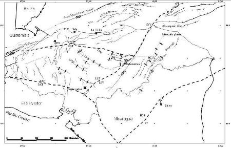
I had already talked about This before, but in this case I want to project a map that is not on my hard drive but online. This is the case of the geological fault map of Honduras, which is available on the website of Dr. Robert S. Rogers.
1. Georeferencing it
First, we downloaded it and placed it on the hard disk.
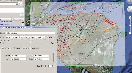
For this purpose, and since it is a sheet with a scale greater than 1 in one million, georeferencing it to Chilazo It's enough. This is done by importing it as an overlay image and then stretching it until the boundaries match; if you had end coordinates, it would have been more accurate to insert them in lat / lon.
Otherwise, I have arranged an approximate 65% opacity.
Once this is done, it is saved as kml of just 1 kb.
1 Modifying the kml
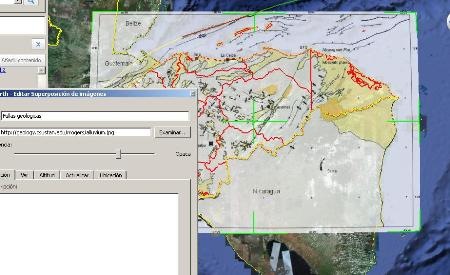
First, let's see that the kml does not contain the image, but refers to a place where it is stored:
Geological faults
91ffffff
http://geology.csustan.edu/rrogers/terranes.jpg
0.75
16.77506106182943
12.24368463513841
-82.69883751605062
-89.70371452334636
So to create kml files of the other images, you would only have to edit the file with a notepad, changing the address of the local disk for that of the image hosted on the web and the name. Be careful, with the notepad you can edit a kml file, not a kmz because it is a compressed file.
This can also be done from Google Earth, modifying the properties of the layer. See that just by changing the url, for any of the maps available on that website, I can make the display because they were exported in the same layout.
By the way, see now by showing the epicenters of the earthquakes that have occurred since the year 1970.

Here you can See kml Of the example.
This Another item Speaks of failures displayed in a published service


Google Maps does not have options to adjust the opacity, without touching the API
Does this kml work the same for google maps too?… because I tried it but the opacity doesn't work 🙁… how can I change the opacity so that it works in google maps…
Excellent !!, Now!
Thank you.
Allan
Then superimpose, select the image in the left panel, right button and choose properties.
Then you see the corners in green, which you can stretch as you like, just like the center button to rotate it.
Very interesting the recipe, but I do not know how to stretch or shrink the image after importing it as a superimposed image. No tool or command is activated. How's the thing ???
Best regards and thanks again for the flop.
Allan López
Costa Rica