Talking to the people of Tuent
This week has been published in Directions Magazine an interesting interview Ernesto Ballesteros of the company Tuent, which in just 6 questions brings valuable content to the geospatial community.
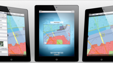
 Tuent is an innovative service that, among other things, offers the possibility of setting up territorial dashboards. It does not take up much space so that maps can be placed online, integrated with statistical data and linked to Excel tables. For now, the service is available for the United States, Mexico and Spain, but because of its innovation, its determination and speed at which it has been integrating maps from other countries, I am sure it will grow much further; They even have openings for partners who wish to represent them in other countries.
For companies, local governments or political parties, it is an almost unbeatable alternative, because with little effort you can take advantage of geomarketing, and everything in the cloud. There is a free version called Tuent free; for those who expect more, Tuent premium, with whose service it is possible to integrate not only the maps that are seen in the free version and the ability to customize users, accesses or territories is another world.
Insurance will eventually create new personalized services targeted to specific sectors, as is the example of the pharmaceutical medium for which the Geofarma service is doing very well.

I leave the first answer, as an example worth reading.
1. Who are you? Do you come from the technological market or from the specific Geotechnology market?
We are a relatively young company with a totally Spanish capital, formed by a human team whose common denominator is that we have always dedicated ourselves to the geotechnical world, although from different perspectives. Some, as is my case, we started in the production of cartographic data for different Public Administrations (Cadastre, Autonomous Communities, etc.), and later we dedicated ourselves to the GIS analysis. The development department is made up of programmers who also come mostly from the GIS world. Our General Manager, Telecommunications Engineer, also held executive positions in companies in his sector in the past, specializing in the implementation of applied geospatial solutions.
These are the following questions that were asked to you, that no doubt upon seeing the complete thread, added to the previous interview with Geomarketingspain you can have an inspiring picture of successful initiatives in the geospatial field.
2. Many of our readers are developers or analysts in the Geospatial sector and are almost always interested in the “guts” of these products. What technological platform do you use? Do you plan to migrate to payment solutions? how complicated is it to integrate tuent with other corporate data services?
3. The technological developments based on Geomarketing can serve a multitude of business models. What is the type of customer you want to reach? Do your clients need specific technological knowledge for the use of your services?
4. For those potential clients that do not know you yet What kind of services does your service offer? Can you give us some kind of rate?
5. You who are already moderately knowledgeable about the market do your customers know the Geotechnologies or are you the ones who have previously had to make an effort to make known the possibilities of them?
6. As you have already mentioned, you have been developing this type of services since 2006. At what stage of development is your service pull? How do you predict that this kind of GEO services will evolve in the future? Do you plan to propose mobile solutions based on geomarketing?
More news can be seen in the blog of Tuentfree and in his Facebook group.