The best of 2012 in Geofumadas
Ending this year, this post pulls out two outstanding articles from each month. Although I would have wanted to make a good April Fool's Day joke like other years, the vacation has taken my family time, trying to regain strength for a new year that will surely be demanding.

Some of these entries have several hours of work, such as the analysis of the best version of AutoCAD, others are outstanding in innovation such as GPS Posify, others represent priority days in the year. Here the list.
January
Import Google Earth image into ecw format
Generate technical memory of plots with CivilCAD
February
Excel to Google Earth, from UTM coordinates
AutoCAD 3D course on your door, for $ 34.99
March
4 What's new in Google Earth 6.3
Pointools, the steroids of Bentley Descartes
April
Template to convert decimal geographic coordinates to degrees / minutes / seconds, then to UTM and draw the polygon in AutoCAD
May
Stay inspired! Letter to my collaborators
June
The Great Year of Google Chrome
Of the coups d'etat of Honduras and Paraguay
July
What has been the best version of AutoCAD?
August
GvSIG course applied to Territorial Ordering
GPS and Google Earth in Cooperation
September
Comparison table of almost 50 total stations
Portable GIS Version 3, almost everything from a USB
October
Posify, low-cost GPS centimetric accuracy
Sokkia Series 50 Total Station Manual
November
Understanding the BIM concept, in the case of Bentley Systems
What are Bentley and Trimble up to?
December
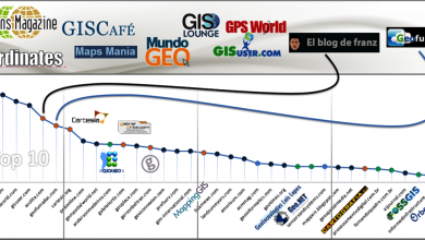
Influence of 10 + Twitter accounts in the geospatial environment