The GIS Free Book
It is perhaps one of the most valuable systematization products in the Spanish-speaking environment under the geospatial theme. Not having this document at hand is a crime; Let's not say ignorant of the project before reading it in this Geofumadas article.
It is very likely that a product like this will not be found in a publishing house in the Hispanic environment, I would dare to think that beyond; and it is that the document was born with the idea of creating a reference product for the geospatial subject before the constant evolution and the danger of bias on the part of a specific software. Definitely an invaluable document prepared by Víctor Olaya, with the collaboration of acquaintances in the geospatial environment, including Landon Blake, Miguel Luaces, Miguel Montesinos, Ian Turton and Jorge Sanz. Although Víctor Olaya is a polyglot who has written and composed on a variety of technical and artistic topics, in this he seems to have collaboratively penetrated with this team in a very particular way, almost - I imagine - as when he was geofuming the SEXTANTE initiative , which surely must have been an intense moment.
We refer to the GIS Free Book, Which may well be a reference document at the time of writing on a topic, elaborate a presentation, build a system, teach lectures or simply learn more about Geographic Information Systems.
It is not only important because it is free, because it is Hispanic, because it is ours, but because we are in a time where the dispersion of PowerPoint presentations, learning communities, blogs and sites where information is shared contribute but do not consolidate in a consistent way the construction of hard documents that serve as conventional bibliographic reference. This background and the endorsement under which this book was built give it the authority to be taken into account by the community beyond the sense of admiration that we recognize in passing.
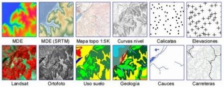
It consists of 8 chapters that include 37 topics built with a logical sense: the first two chapters focus on theoretical and conceptual aspects, as the third and fourth chapters progress we realize that many things we thought we knew about construction Geographic Information Systems involves multiple disciplines that go beyond our curriculum and do nothing but challenge our self-taught canine. I like the chronology of the introductory stages of each section, based on the common thread of what the user expects. Although the document type does not lend itself to developed examples, it does not lose the practical focus.
Chapter 7 closes with use cases specifically in the areas of ecology, risk management, and planning. Then in the annexes it is explained that there is a complete set of data from Baranja hill, In Croatia, which can be downloaded for the purpose of implementing the theme.
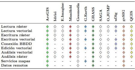
Also in the annexes a panorama of the software applied to the GIS in the current era is synthesized. A brief analysis of both free and proprietary software is made, mentioning in the case of desktop clients: ArcMap, Geomedia, Idrisi, PCRaster, Mapinfo, Manifold, Erdas Imagine and Google Earth. Regarding free software, gvSIG, Grass, Quantum GIS, SAGA, World Wind, Open JUMPy UDig; Without leaving out the review of database managers, metadata, web publishing and libraries.
I suggest downloading this document as it is now -Which in itself already weighs 65 MB- Although it is a project, we hope it will continue to update. To finish convincing you, here I summarize the index of the 915 pages that only need a good cover.
I. The fundamentals
1. What is a GIS?
2. History of GIS
3. Cartographic and geodetic bases
II. The data
4. With what work in a GIS?5. Models for geographic information
6. Main sources of spatial data
7. The quality of spatial data
8. Databases
III. The processes
9. What can I do with a GIS?10. Basics for spatial analysis
11. Queries and operations with databases
12. Spatial statistics
13. Creating raster layers
14. Map algebra
15. Geomorphometry and terrain analysis
16. Image processing
17. Creating Vector Layers
18. Geometric operations with vector data
19. Costs, distances and areas of influence
20. More spatial statistics
21. Multidimensional Analysis
IV. The technology
22. What are GIS applications like?
23. Desktop Tools
24. Remote servers and clients. Web Mapping
25. Mobile GIS
V. The visualization
26. GIS as visualization tools
27. Visualization and Representation Basics
28. Map and cartographic communication
29. The visualization in GIS terms
SAW. The organizational factor
30. How is a GIS organized?
31. Spatial Data Infrastructures
32. Metadata
33. standards
VII. Practical applications and uses
34. What can I use a GIS for?
35. Risk analysis and management
36. Ecology
37. Resource management and planning
VIII. Attachments
A. Data set
B. Current Overview of GIS Applications
C. About the preparation of this book
Download Free GIS Book


Well I want you to send me the complete manual of only the attribute table
The link is functional
http://sextante.googlecode.com/files/Libro_SIG.pdf
Correct download link
Error in download link
It is a very complete and clear book. Excellent contribution!
what a good book, I'm complete ...
For those of us who like the GIS world, it is a great contribution, to expand our knowledge. Thank you very much for the book.
Thank you very much for giving the book diffusion !! Let's see if I can get it soon so the printed version can be purchased.
Thanks again for the article
Victor
I have corrected the link to another source where it can be downloaded
http://sextante.googlecode.com/files/Libro_SIG.pdf
It is an 62 MB file
There is no download link, is the book still available?
I tried to download it but I just downloaded an 58kb link in .zip. Did anyone have the same problem?
Thanks for the guide to that book, I come to see that I take it and help me
I find the content of this book very interesting and professional, I work sometimes with the GIS, working with the ARCGIS Program, of ESRI and I will use it for my consultations. Thanks and friends.