
The CadCorp family of products
Recently we had shown family products from the ESRI industry, both ArcGIS for desktop as Extensions more common.
In this case, we will talk about the CadCorp family of products, in this case the desktop applications. 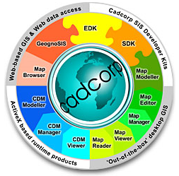
One of CadCorp's main statements is its insistence on supporting the standards of the Open Gis Consortium (OGC) Which is an international initiative focused on defining an extensive collection of open interface specifications for GIS.
Another aspect that CadCorp makes a lot of emphasis on is the availability of plugins to be able to read, import, export or interact with data from other CAD / GIS industries such as ArcGIS, AutoCAD, Microstation, Mapinfo, Oracle, SQL and others.
Also interesting is the plugins to access data Shared in various sources such as GeognoSIS.NET (OpenStreetMap, Google Earth KML, NASA and SIA dataMap), as well as GeoRSS, GPX, ArcIMS.
CadCorp's way of handling data is very different from the mxd logic of ArcGIS and is very similar to that of Manifold, although external databases can be handled, the database and the map can also be manipulated. A single file. Previously the formats used were .bds, currently the .sds format is used, this allows several concurrent users in a single file.
 CadCorp base products have the same Business model ESRI, in the sense that the MapViewer to Map Modeller tools are equivalent to ESRI's ArcReader to ArcInfo tools. Although this comparison is only on the "scalable" business model, CadCorp has some capabilities that ArcGIS does not have. The advantage is that the extensions are not scattered among hundreds of ESRI extensions although it seems that the quality of the deployment and final products do not achieve the same fineness as the products generated with ArcGIS or manifold.
Desktop Tools
1. Map Viewer
This is a map reader, Equivalent to the ESRI ArcReader, allows you to view more than 160 GIS / BD data formats among them generated with ArcView shp, Ordnance Survey NTF and Mastermap, MapInfo MID / MIF / TAB, AutoCAD dwg and dxf, Microstation dgn, ecw, GeoTiFF, FME, XML, GML, MrSID, Oracle Spatial, and more. It contains the basic functions of layer display, thematic display, tabular display, printing and some other elementary functionalities.
Previously Map Viewer Was free, currently is not, and released to the market for free Map Reader Although with this only you can see files generated with Cadcorp products in pwd format.
2. Map Manager
This is known as a map manager, Equivalent to ESRI's ArcView and allows you to capture, edit, manipulate, visualize, analyze and export spatial data. An interesting feature of CadCorp Map Manager is that almost any task has a wizard to run, mainly spatial search, thematic presentation and printing are valuable. It has about 250 coordinate systems for map reprojection, which can be done on the fly and layers with different projections can be displayed on the same map.
Another interesting aspect is the fact of converting a generated map of a thematic analysis into a new map, with just one click… maintaining a relationship with the original!
3. Map Editor
This is known as the Map Editor, and it offers the Map Manager tools, adding extended data capture and "CAD-style" editing tools, although they always leave a lot to be desired, they are a little more robust than ArcView and not as much as ArcView. from Manifold. It also has some advanced tools for spatial analysis, advanced database creation, and topological analysis. It is an equivalent to ArcEditor in the ESRI family.
It also has Map Editor capabilities such as the ability to store data in Binary Large Objects (Blobs), Iformix Spatial Datablade, OpenGIS SQL and extended database access through Active X Data Objects (ADO).
 4. Map Modeller
This is known as a map modeler, and adds advanced analysis, three-dimensional management features, including surface generation, extrusion, support of digital terrain models (DTM), you can also hunt a raster image on the Surface modeled and has OpenGL visualization capabilities. It is unequivalent to ArcInfo in the ESRI family.
In another post we will see its extensions for development.
Official page of CadCorp: http://www.cadcorp.com
Useful CadCorp downloads:


