
Pict'Earth results
Well, We have already torn apart To the children of Pict'Earth, now we return the merit because through its innovation, it is possible to find images with better resolution and newer than those of Google Earth ... as many join their initiative ... or that Google feed their idea .
Let's do the test, by the way we learn to know what date Google Earth images have.
This is near San Diego (I take this opportunity to tell you that there will be the ESRI Conference, and it is worth it if you invite me huh… I promise to behave 🙂)

1 Finding images of different years

To know the different images available in the area that interests us, this layer is activated in the left panel, just as we did with SPOTs.
If we move away we can see the mosaic of coverage, turning them on every year looks clearer.
Well, clicking on the icon you can see the basic data such as the catalog identifier, cloudiness percentage and quality that can be translated as sharpness, I suppose.
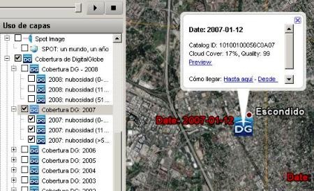
Now clicking on the link called "Preview" shows the image as it is sold by Digital Globe ... upon simple inspection you can identify if any of them is the source for the image that Google Earth shows if it is from Digital Globe, but incidentally I tell you that Google uses different sources, in this case it is from Tele Atlas, so it appears below in watermark.

Warning, there is no way to change this visualization in Google Earth, it is only to see if it is possible to acquire a better quality image at a lower price. In the url shown you can enter Digital Globe and make a more specific selection such as We explained it in the SPOT images.
2 The results of Pict'Earth
Surely services like these must have others there, if they are not being incubated because the idea is very good ... if you Follow the procedure.
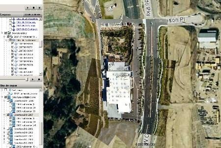
Well, this is the coverage of Google Earth, see that this whole area has no urban development and observe the cut to the right between the old and the oldest image 🙂

 Now, I have gone down from Pict'Earth a kml of the missions and coverages that they have made and I have opened it with Google Earth.
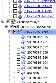
In this search of the layer of "Groundoverlays" of Pict'Earth, which for educational purposes I have selected to provoke your curiosity in a perverse way :).
Then I select the folder called "2007-06-15 Stone Brewery" and the image called ask.com.
We see then how in the coverage of Ask.com, that these guys have gotten as jpg, stored in Flicker and stretched to the rogue in this area.
The result is the development of a shopping center and streets of that area still under construction.

Now when activating all that folder, you can see the images that flew and stretched with your little plane until you hit with "The precisions"from Google Earth.
3 conclusion
 The idea is very good and we applaud the creativity of Pict'Earth, Orthophotos in near real time, if it is possible to automate it, providing products on demand and at low cost. I myself would be very interested in acquiring them if the precision and relevance could be systematized.
The risk is the same, that Google Earth buys them the company and let's start seeing small planes everywhere as well as Cars Street View ... and there if we would have aerial porn without sense.
Of course, if Google does this, it will take a walk in all of us, as there will be updates at all times of many places and if they create a way for people to collaborate sooner or later we will have the same madness of the localities or businesses updating By the users.
At what precision? ... well to them 30 meters from the Google tanteometer, hehe.


You are complete loko….