
The same story, now with GPS
... In that Empire, the art of cartography achieved such perfection that the map of a single province occupied an entire city, and the map of the empire, an entire province.
Over time, these inordinate maps did not satisfy and the schools of cartographers raised a map of the empire, which had the size of the empire and agreed punctually with him.
Less addicted to the study of cartography, the following generations understood that this dilated map was useless and not without impiety they gave it to the inclemencies of the sun and the winters.
In the deserts of the west, torn ruins of the map, inhabited by animals and for beggars; in the whole country there is no other relic of the geographical disciplines.
 It is curious that this story was written for the first time by someone named Suárez Miranda, in 1658 (not even Txus was born 🙂) in a book called "Travel of prudent men."
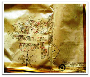
It sounds familiar because Jorge Luis Borges cited it in his work "Universal History of Infamy" in 1957, but it has the same validity of the terms of reference that I just saw for a cadastral survey.
Minimum circular errors of 10 cm. For a rustic upwelling in a moist forest area? No, thank you, I spend the evening boring my select readers with the poetic part that few know me
… In that country on this (the other) side of the Pyrenees, art for the geomatics reached such levels of precision, that the vertices of each property coincided with the stream, with the pixel, with the micron vomited by the oracle of Google Earth.
Over time, precise maps did not fill the mortician intentions of geometers, and they decided to make an ellipsoid that would be able to adjust the geodesic grid, at the rate that the tectonic plates moved in continental drift.
Its level of accuracy was such that the inconvenience of multiple directions in which the 15 earth tectonic plates move was adjusted in a Da [geoid] tum that adjusted the coordinate system to adapt to the altitude of each centimeter of the earth , so that a model was made for each line drawn in latitudes and longitudes of 5 seconds ... and then in view that the flight of the birds hindered the radar capture ...
Are they still there?


jejeje, how much work is done up to three times by criteria of better precision so that in 10 years we again say that the absolute georeference was bad
... many years went by in which precision was a flag raised with pride until a guy came up with the idea of relating databases of the Earth with a Great Mount of Mars, since apparently, the gravity that that exerted on the Earth was causing micro miscalculations… and everything went to hell again….! =)
Very good delirium to start relaxing on this Friday ..!
regards