
The UTM coordinate systems displayed in Google Maps
It does not look like that, but the resource that PlexScape Web Services has Transform coordinates and visualize them in Google Maps Is an interesting exercise to understand how coordinate systems work in different regions of the world.
To do this, select from the panel that displays Coordinate Systems, the country and then appear above the different Coordinate Systems and Datum that the service has integrated with the zones that apply. By clicking on the magnifying glass, you can see the geometry drawn on the map as shown in the image of some used in Brazil.
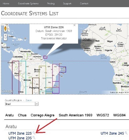
I take to summarize those that could be of interest in our context although there is for all the other countries and even some that apply of regional way like Europe, South America, etc.
Country |
Coordinate Systems |
| Argentina |
Inchauspe Field Pampa del Castillo |
| Belize |
WGS72 |
| Bolivia |
Provisional South American 1956 |
| Brazil |
Aratu (mangrove tree crab) |
| Canada and United States |
For these two countries there is a system almost for each state, apart from the systems of regional scope |
| Chile |
Provisional South American 1956 |
| Colombia | Bogota MAGNA-SIRGAS Provisional South American 1956 South American 1969 WGS72 WGS84 |
| Costa Rica, El Salvador, Honduras |
WGS72 |
| Cuba |
NAD27 (CGQ77) |
| Dominican Republic. Haiti |
WGS72 WGS84 |
| Ecuador |
Provisional South American 1956 |
| Spain |
ETRF89 |
| Guatemala |
NAD27 (Definition 1976) |
| Jamaica |
Clarke 1866 |
| Mexico |
GRS 1980 |
| Panama |
South American 1969 |
| Paraguay |
South American 1969 |
| Peru |
Provisional South American 1956 |
| Portugal | Azores Central Isls 1948 Eastern Azores 1995 Azores Oriental Isls 1940 Datum 73 ETRF89 ETRS89 European 1950 Lisbon Hayford Lisbon (Lisbon) Lisbon 1890 (Lisbon) Wood 1936 Porto Santo 1936 Porto Santo 1995 WGS72 WGS84 |
| Puerto Rico |
WGS84 |
| Uruguay |
Aratu (mangrove tree crab) |
| Venezuela |
Provisional South American 1956 |
For all these systems, with their different zones you can visualize coordinates in Google Earth in both projected and geographical units. There is also a message from them, that if a particular system is not there, they integrate it if they are reported.
Go to page


Google uses WGS84
Hello good evening I want to know what is the coordinate system that I can use to reproject some data that I have from Panama in Google Earth in a kmz, they are in WGS 84, apparently I must use Nad27 but when transforming the information it says that it does not have a defined coordinate system, on the other hand if I tell it to define it, in effect it "transforms" it but, it is poorly projected, what should I do? Thanks for answering