The topics of the Congress of Guatemala Surveying
Just completed Congress of Land Management and Surveying held in Guatemala the previous month, the presentations of the exhibitors have been posted. They are available in a single page, although it is more practical to see them in Slideshare, from where they can be downloaded.
I suggest downloading them and saving them in a personal file, considering that in these times nobody guarantees what is on the web. It is also a great material that can be used when giving training in the cartographic area.
Then ready the ones that are available, in an approximate order to the theme.
|
|
 Potentials for territorial development in rural regions. Potentials for territorial development in rural regions.
Experiences initiated by peasant organizations. Dr. Cesar Eduardo Ordoñez, |
|
|
|
E
SEGEPLAN A good overview of what they are doing in Guatemala; Told by someone who was there from the beginning in this new stage. Many challenges too ... |
|
Very good, showing how the Cadastre is evolving, and valuable the constant links it gives to promote the work of the Lincoln Institute or publications. |
|
C Diego Erba, Lincoln Institute for Land Management Diego is masterful in this, I like his presentation style, with a strong visual impact. Although if you weren't at the event… you missed almost everything. |
|
This exhibition shows how the Cadastre works in the Netherlands. A totally different context from ours, but in which processes such as that of CNR in El Salvador have been inspired. |
|
Interesting smoke, on the trends of the 3D issue in the Cadastre. A pity, that in our context it is not a priority when 2D is still a challenge, however it is useful to know it because that is where developed countries are going. It is also an attraction for large cities, such as Mexico City, Bogotá, to put examples of our context where it may be urgent. |
|
|
|
Lincoln Institute for Land Management Interesting, a valuable sample of the mapping of cadastral values; A challenge its updating. |
|
This is our presentation on the trends that are happening in the Central American context on the use of technologies for territorial management. |
|
Javier Morales, ITC This is in English, an interesting presentation on data construction from community collaboration. The most sustainable example of this is Open Map Street. Although the subject seems astral, very well handled by Javier who knows this group because he often comes to give courses or conferences. Very good reflection at the end, which I completed in the talk of Return to the capital. |
|
Both this and the following presentation are ideal to know the operation and trends that are having the OGC standards. |
|
A classic is this presentation, which shows how geoservices have been implemented in Guatemala. The reception that gvSIG has had as an IDE client, plus the MapBender plug-in, is interesting; then GeoServer / Apache for handling WFS and MapServer for WMS / WCS. |
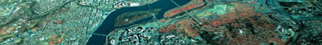
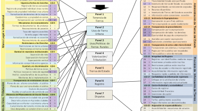
 Approach to the Concept of Territorial Development
 Urban and Rural Challenges of Guatemala of the 21st Century
 Of the Land Administration in Guatemala
 The cadastre as a tool for territorial development
 To share: the role of information for land administration
 Land administration in the Netherlands
 Developments in the world of land administration: domain models in land administration, cadastres in 3D and key registries
 Use of cadastral information as a basis for land use planning plans
 Municipal Cadastres - Opportunity or headaches for our cities?
 The introduction of new technologies in the cadastral projects of the region
 Crowdsourcing and Geographic Information
  Use and Consumption of Geoservices for the IDE
 SINIT: a first step for FDI in Guatemala?
A great job, the one from SEGEPLAN and the University of San Carlos, In keeping this issue alive in the region.
See the presentations on the Congress page
View presentations In Slideshare