
Bentley Systems makes a huge bet for the GIS when acquiring Agency9
Since 2004, when Bentley incorporated XFM in to its new V8i developments, Bentley had been adding spatial features that went from the Geographics legacy to Bentley Cadastre, PowerMap and BentleyMap. However, it had always been engineering technology, which also made geo with the high level of CAD precision required by the engineers, surveyors and architects.
For us who use BentleyMap all along, since its inception with the Geospatial Administrator, we were always expecting to when the next step could be seen. With great satisfaction, the news that Bentley Systems has acquired the creative company of CityPlanner and 3DMaps is only demostrates the potential accumulated by this initiative born in 2003 in Sweden, from primitive versions of spatial data visualization to web deployment solutions and collaborative integration of high performance to this day; just a time when the geospatial potential has grown both in the OpenSource and privative.
Now that we are part of Bentley, we are confident of reaching the full global potential of Agency9 innovations. - Håkan Engman, CEO of Agency9.
Agency9 added important implementations in Nordic cities, an area where the Microstation line has been well received; I still remember BeAward of 2004 in Orlando fresh, when the Helsinki Cadastre show its samples in a competition of the Environment Management category. It is also important to recognize that listen the users has certainly influenced Bentley to focus on this solution which is being implemented in many cities in Sweden, with the ability to integrate photogrammetric data from Bentley ContextCapture.
What products have Agency9?
Talking about products is somewhat limited, considering that these do not always make visible the potential behind a technological concept, in addition to that Agency9 served them separately although together they represented the same collection that we now assume Bentley will integrate transversally into the Digital Twin line. Services. To give a sample of this, Agency9 has at least four solutions with a lot of potential:
CityPlanner
Based on the cloud, this solution is focused on collaborative planning. It allows to visualize 2D, 3D and GIS data in a three-dimensional environment. Being web or being online, it barely need a browser to work, even in creation mode.
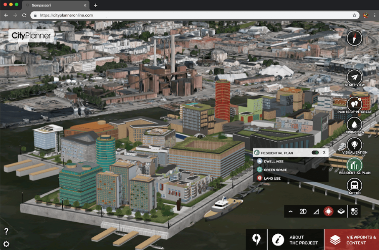
The crazy inspiration of CityPlanner has an excessively efficient stream core, because the 3D display is extremely fast even if it's working with massive data. Therefore, for things like territorial ordering, it has a lot of potential, becausethere can be seen both layers of complex geometries at a national/regional level, and, as layers of urban parcels with three-dimensional definition.
In some of my posts of thetwitter account I presented it as a Google Earth on vitamins.
The best of the best, the capacity of edition, being able to load models CAD, BIM, XNUMXD, raster or coverages of web services. Some of the functionalities remind us of the contextual actions of the web editor of OpenStreet Map, but with much more features of course, and a valuable practicity, almost -but not so much neither - as if we were playing CityVille. You can work collaboratively, so that based on roles, the team operates in controlled workflows.
3D Maps
 This is a tool set with the SDK, for the construction of 3D models, with the facilities of the recently popularized disruptive photogrammetry of texturized model: DSM, Smart3DCapture, StreetFactory, PhotoScan, 360 views, oblique images and services with OGC standards.
The runtime version have the minimum, but with the sdk you can build new 3D-GIS developments, mostly with JavaScript.
DBConnect
This is practically a 3D viewer of spatial data, making it possible to connect in edition mode to virtual urban environments locally or in the cloud, individually or in batches, with formats such as CityGML, KMZ, Collada or SQL geometries. It usually comes with 3DCityDatabase as the default.
Something very interesting is that it allows an efficient management of complex geometries with textures, with historical versioning. Ideal for the construction of virtual cities.

DataManager
This is the data manager, which allows the administration of sources in different formats or services. Among these we can find:
- Surface models DSM / DTM: GeoTiff, ASCII files
- Orthorectified or georeferenced images: Geo-Tiff / JPG / PNG
- Surfaces with image texture (PhotoMesh): ContextCapture, PhotoScan, SURE, StreetFactory, Rapid3D
- Point clouds: LAS
- Geometric topologies: polygons, lines, points as footprints, trees, urban furniture, etc.
Regarding services, it supports:
- Context coverages in OGC WCS standards
- Map and tile services WMS, TMS, WMTS, Slippy
- ESRI Image Service
- And of the most desired, images from DigitalGlobe ImageService
- Bing
With this acquisition, Bentley obtains an impressive potential to materialize or generate its Digital Twins at the level of urban areas, with the CAD and BIM potential required by the trend of holistic designs like SmartCity.
About the acquisition of Agency9
Bentley has made the announcement of this acquisition, at the Year in Infrastructure Conference , where, in company of Topcon, Siemens and Microsoft, present the trends of the Pavillion Alliance and award the best projects that have innovated in the field of Geo-engineering.
It's immediate integration will surely be ContextCapture of Bentley, as a digital context to visualize urban infrastructure assets represented in GIS data, terrain models and BIM, structured in the new iTwin ™ cloud services, presented at the conference. Interesting wager, at a time when the two giants ESRI and AutoDesk line up or join forces as other competitors are doing in virtual environments, with an approach of GIS-CAD barriers, in theevolution of the BIM.
It will be important for BentleySystems to make a comprehensive adaptation not only of the interface, but also to the i-model, as it has done successfully with other solutions it has acquired. This will be a strong challenge, especially with the trend we see; where competing GIS solutions have taken the correct reading of the web trend, despite having had a successful positioning in desktop software, a situation in which achieving the balance should not be easy, before the user who looks too extended the timeline that It takes to migrate and simplify everything to the new web context.
On behalf of Bentley, Phil Christensen, senior vice president said:
Our users in many cities have been requesting the necessary capabilities of what Agency9 has successfully implemented on all Sweden, to take advantage of its reality modeling programs. In fact, when we combine the photogrammetric capabilities of Bentley ContextCapture -which includes hybrid images obtained by aerial autonomous vehicles - with our technologies of Connected Data Environment (CDE) for the geospatial integration to BIM, makes the Digital Twins at city scale be a efficient cloud service.
The reality and the 'virtuality' of CityPlanner, offers the perfect web solution to allow that the information can mutate and to be preserved of controlled and precise form."
Congratulations for the users of Microstation, who will be able to expect fresh geospatial functionalities integrated to the vertical AECO industries that currently operate on ProjectWise and AssetWise.


