
View Google Earth coordinates in Excel - and convert them to UTM
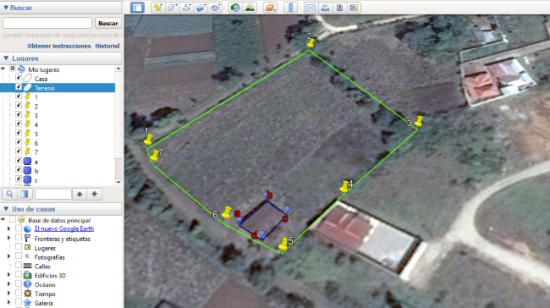
I have data in Google Earth, and I want to visualize the coordinates in Excel. As you can see, it is a land with 7 vertices and a house with four vertices.

Save Google Earth data.
To download this data, right click on "My places", and select "Save place as..."
For being a file that has lines, points and properties that I have modified to the icons, the file will not be saved as a simple kml but as a Kmz.
What is a KMZ file?
A kmz is a set of compressed kml files. So the easiest way to unzip it is as we would with a .zip or .rar file.
As shown in the following graphic, we might not see the file extension. To do this, we must do the following:

1. The option to see the file extension is activated, from the “View” tab of the file explorer.
2. Change the extension from .kmz to .zip. To do this, a soft click is made on the file, and the data after the point is modified. We accept the message that will appear, which tells us that we are changing the file extension and that it could make it unusable.
3. The file is uncompressed. Right mouse button, and select "Extract to...". In our case, the file is called “Geofumed Classroom Land”.
As we can see, a folder was created, and right inside you can see the kml file called “doc.kml” and a folder called “files” that contains the associated data, generally images.

Open KML from Excel
What is a Kml file?
Kml is a format popularized by Google Earth, which was before the Keyhole company, hence the name (Keyhole Markup Language), therefore, it is a file with an XML structure (eXtensible Markup Language). So, being an XML file it must be able to be viewed from Excel:
1 We changed its extension from .kml to .xml.
2. We open the file from Excel. In my case, that I am using Excel 2015, I get a message if I want to see it as an XML table, as a read-only book or if I want to use the XML source panel. I select the first option.
3 We search the list of geographic coordinates.
4 We copy them to a new file.
And voila, now we have the Google Earth coordinates file, in an Excel table. Starting from row 29, in column X appear the names of the vertices, and the latitude / longitude coordinates in column AH. I have hidden some columns, so that you can see that in rows 40 and 41 you can see the two polygons that I drew, with their chain of coordinates.
So, with copying the X columns and the AH column, you have the objects and coordinates of your Google Earth points.

We hope that the above has helped you to understand how to save Google Earth data in a kmz file, as well as to understand how to pass a kmz file to kml, finally how to view Google Earth coordinates using Excel.
Interested in something else?
Convert data from Google Earth to UTM.
Now, if you want to convert those geographic coordinates that you have in the form of decimal degrees of latitude and longitude to a format of projected UTM coordinates, then you can use the template that exists for that.
What are UTM coordinates?
UTM (Universal Traverso Mercator) is a system that divides the globe in 60 zones of 6 degrees each, transformed in a mathematical way to resemble a grid projected on an ellipsoid; such as is explained in this article and in this video.
As you can see, there you copy the coordinates shown above. As a result, you will have the X, Y coordinates and also the UTM Zone marked in the green column, which in that example appears in Zone 16.

Send data from Google Earth to AutoCAD.

In order to send the data to AutoCAD, you just have to activate the multipoint command. This is in the “Draw” tab, as shown in the drawing on the right.
Once you have activated the Multiple Points command, copy and paste the data from the Excel template, from the last column, to the AutoCAD command line.
With this, your coordinates have been drawn. To view them, you can Zoom / All.
You can acquire the template with Paypal or Credit Card. When making the payment, you receive an email with the download link. Purchasing the template entitles you to email support, in case you have a problem with the template.
Learn how to make this and other templates in the Excel-CAD-GIS cheat course.


It's a shame, more or Google Earth does not allow the creation of polygons with precisão aceitáveis characteristics. É melhor fazê-lo em outro GIS program and send it to or Google Earth.
Greetings
Oi geofumadas !!
How can I add a polygon not google earth?
It is important to place the first points and add them or polygon in a normal way in order to delimit the area. But what happens when quando faço or Zoom gives area of work, or ponto não sobrepõe ao or polygon, deixando a huge distance of error between or polygon eo ponto.
Ou seja, I need to add a polygon not google earth (It could be from excel, melhor)
I hope that I adjust and muito obrigada!
File chuyển đổi này rất hay và tiện ích, anh cho em xin file chuyển đổi này với, email nguyenbahiep775@gmail.com. Rất cảm ơn anh.
In this link are the different excel sheets that you can acquire to transcode coordinates
https://www.geofumadas.com/conversor-de-coordenadas-utm/
hi geofumadas, excellent tips for the use of google earth, it helps me a lot in my work.
a support, where I can download FORM TO TRANSFORM LIST OF GEOGRAPHICAL COORDINATES (X, Y, Z) TO UTM, I need it.
I wait for your comment
regards
fabio