AutoCAD-AutoDeskMapsDownloads
Convert decimal geographic coordinates to degrees, to UTM and draw in AutoCAD
This Excel template is initially made to convert geographic coordinates into UTM, from decimal format to degrees, minutes and seconds. Just what Contrary to the template we had previously done, As seen in the example:
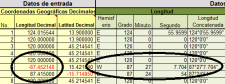
Additionally:
- He concatenates them in a chain
- Converts them to coordinates UTM, With option to choose a Datum
- Concatenate the dot command to create points in AutoCAD with a single Copy / paste
- Concatenate the polyline command to draw the traverse with a Copy / paste
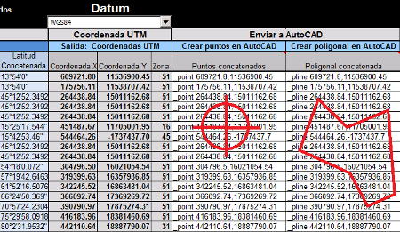
How is the operation of converting geographic coordinates in UTM done:
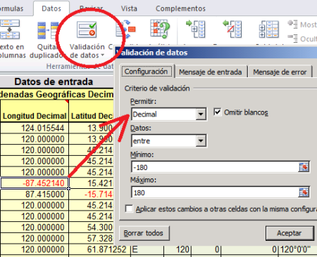
- To condition the input fields, properties are placed on the cells. This is done with the Data tab, in the data validation option. We chose that there only support decimal data between -180 and 180, which is the maximum that supports the lengths. And then the error message indicates that the data is not allowed. In the case of latitudes, it is indicated between -90 and 90.
- To choose the hemisphere in lengths, which are in column G, the cell conditions, that if the coordinate is negative the W text is written, if positive text is placed E.
This is done with the formula =YES(G37<0,”W”,”E”)
- Similarly with the latitudes in column H, if the coordinate is negative, write the letter S, if it is positive N.
The formula will be =YES(H37<0,”N”,”Y”)
- To extract the degrees, the absolute value is used and the number is truncated to zero decimals = ABS (TROUBLE (G37,0)) In this way, a -87.452140 will be converted to 87
- To extract the minutes, the original value is subtracted from the truncated value, so that only the decimals remain (0.452140) and that value is multiplied by 60, which is the total number of minutes in a degree. It is truncated to zero decimal places and thus it is obtained that in 0.452140 there are 27 minutes = TRUNC ((ABS (G37) -J37) * 60,0)
 To obtain the seconds, the decimals (0.452140) are multiplied by 3600, which is the number of seconds in a degree (60 × 60), and we subtract what we have already subtracted before, which are the minutes (27) multiplied times 60. Then a rounding is applied, with a reference cell where the number of decimal places is so that it can be adjusted to taste. Thus, there are 7.704 seconds. =REDONDEAR((((ABS(G37)-J37))*3600)-(K37*60),$L$5)
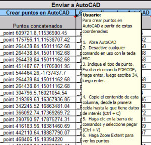
- To concatenate the point command, the _point string is applied, so that only the cells are copied to the AutoCAD command line =CONCATENATE(“_point “,ROUND(S37,2),”,”,ROUND(T37,2)). Similarly, the polyline command =CONCATENATE(“_pline “,ROUND(S37,2),”,”,ROUND(T37,2)). Rounding is applied so that chains are not too long.
In the template there are some tips to execute this last action.
From here you can download the template, paying with Credit card or Paypal.




brilliant
We re-send it to your email.
I am waiting for the download of the excel template
tell me, what is happening strange.
If you purchased the template, request support through the mail with which you received the download link
Dear the conversion to UTM is not correct, values are not correct, please help if I am doing something wrong
I appreciate your comment but you have not understood. The article explains well how you can do it yourself, just as I did it.
Check mail, including spam. If you have more problems contact us to the email that appears on your receipt.
I can help please, I made the purchase with my card and I can not download the help template by favooor
Ha, you missed it.
All template is free the first two weeks after publication, then the download is charged.
: )
It is bad news that the templates sell, I know that it is hard to do them, but good thing we are going to do, the friends of Geofumadas avaces are half hard lol.
Already enabled.
Greetings to.
I would like to pay for many of the plans that are here and I can not
Where I can download; Templates and much more apparently can not (clear via paypal payment) thanks
EXCELLENT! THANK YOU FOR SHARING KNOWLEDGE.
GREETINGS FROM MEXICO.
Excellent! COMMUNICATION AS A SPACE OF KNOWLEDGE
A very useful tool, served me well, thanks friends, greetings from the state of Guanajuato, Mexico
Thank you
EXCELLENT TOOL SIRVIO DE MARAVILLA
Very good staff… .excellent work !! Cheers