
Convert UTM to Geographic Coordinates with Excel
In the previous post we had shown an Excel sheet to convert coordinates Geographic to UTM From a sheet that had popularized Gabriel Ortiz.
 Let's see now this tool that does the same process in reverse, that is, having coordinates in UTM format (Universal Traverso de Mercator) and knowing the area, transform them to latitudes and geographical longitudes.
Let's start familiarizing ourselves with this: according to Google Earth, the coordinates of the Palace of Sports in DF would be X = 489513.59, Y = 2,145,667.38 considering that Google Earth uses WGS84 datum. (for what you do not know, to see UTM coordinates you only go to tools / options / vista3D / show lat / long)
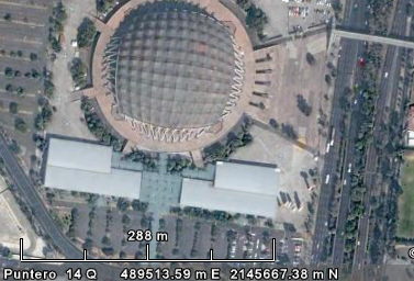
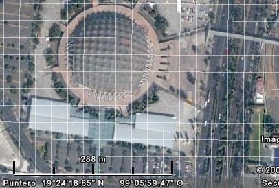
In geographical coordinates, this would be Long= -8 ° -5 '-59 ” , lat= 19 ° 24 ' 18 ”, (to display the grid in google Earth, do “view/grid”)
I recommend that you familiarize yourself with this form of verification and understanding How the UTM coordinates work To get the most out of the tool in Excel.
I've done This sheet that would be very useful to a friend who some time ago was looking to send to Google Earth some data that were in UTM.

1. How to enter data
The fields in yellow pick up the XY coordinates, and also the zone, with this one must be careful enough because Mexico to give an example, the zones go from the 16 to the 21 so that the same coordinates can be in different zones.
The same happens with the hemisphere, as is the case of Colombia, Ecuador and Brazil that have areas in both the northern and southern hemispheres.
Also in the upper part is the reference spheroid with which the UTM coordinates were generated, this is not for the output coordinates but rather for the input coordinates.
2. The output results
The columns in green are the geographical coordinates, the coordinates in the east of the Greenwich meridian will be positive, those in the west will be negative.
3 How to send them to Google Earth
We had already seen some ways to send an Excel file to Google Earth, both geographically and UTM, so take a look, if you want to send the UTM coordinates to AutoCAD, This Excel template allows you to do it.

Here you can download the template to convert UTM coordinates to Geographic.
You can buy it with credit card.
It is symbolic if one considers the utility it provides and the ease with which it can be acquired.
Learn how to make this and other templates in the Excel-CAD-GIS cheat course.


Still in force
All the previous opinions are with past dates, for today September of the year 2020, how are such versions, the technology of that moment is different from today's date, will it remain in force, are there variations?
Hi Javier.
We have sent it to your email. Sure he had gone to some junk mail folder.
Greetings.
Good afternoon,
I just bought the model but nothing came to me. Could you please check the sending of this excel?
Thank you
Javier
By the way, I just discovered this web and I'm fascinated. I still have to get lost in it for a while, but it looks great.
I also do not find where to download it…. 🙁 Where is that wonderful table?
I do not see where to go down !!
Can you give us an example?
I would like to know because when I entered the same geographic range I vote different results for example
Q program for windows vista or excel sheet I can use and download free to convert flat coordinates to geographic or viseversa, I thank you in advance for the attention to the present.
Cordially,
Efrain Peña Borda
PERFECT!!!
Sure, much more than that.
Good day;
I would like to know if with your table I can convert (from UTM to GEOGRAPHIC) many coordinates at the same time. Many are like 1000.
I await your prompt reply, thank you.
We do not have a template to convert GTM to UTM.
I am personally interested in the exel template to convert GTM coordinates TO UTM AND FORMS
Please send me a template count account number
Hello, I have the excel sheet to move from decimal degrees to degrees, minutes, seconds.
Get in touch with me
Thank you, I will see what is the most accessible payment method in which you can do it.
Hello José Luis
No problem, the template contains columns where it supports the input in decimal format.
Once you buy it, contact us and we will tell you how to do it.
Dear, what I want is to be able to plot the coordinates in MicroStation V8i, but my HandHeld captures them in Decimal Degrees LAT W89.14298 N13.71391, and I have to convert them to XY, the Excel template asks for them in Degrees, Minutes and Seconds.
Can help me with this. Thank you
First, thank you for your interest.
Check what you are looking for, as this template converts from UTM to geographic but there are other templates that are sure to do what you want.
Check out the other available templates in this link.
http://geofumadas.com/descargas-utiles/
QUESTION CAN YOU MODIFY THE EXCEL SHEET TO DIRECTLY ENTER DECIMAL GRADES AND AT WHAT COST WOULD HAVE.
No. The one in this article can only convert from UTM to Geographic.
But that of this other article if you can do what you want
http://geofumadas.com/convierte-de-geograficas-a-utm-en-excel/
You can use the spreadsheet to convert geographic coordinates into
UTM coordinates and as
I recommend my page, there is an .exe based on the methodology of Gabriel Ortiz, is not mandatory but I would like to put some comment, I hope you serve, greetings.
http://ghsistemas.jimdo.com/2012/04/04/rutina-lisp-transformacion-coordenadas-utm-a-geogr%C3%A1ficas/
Gustavo
18
How do I convert UTM coordinates to geographic coordinates?
As the template works without inconveniences
If you leave us an example, we can review.
What are the coordinates that you entered, which zone, what results you generate, in which country you are and we check to see what happens. Lest it be a matter of nomenclature of thousands or decimal separations.
Hello, I bought the form, I put the coordinates to convert them but I sent them off the continent. It may be that it is in the area, in this sheet puts zone 15, for Chile what zone should I put?
Hello Shaviola, here we have created the template that interests you
http://geofumadas.com/plantilla-para-convertir-coordenadas-geogrficas-decimales-a-gradosminutossegundos-luego-a-utm-y-dibujar-el-polgono-en-autocad/
There is no template in Geofumadas like the one you occupy. There is one but what it does is the reverse, it converts from degrees to decimals
http://geofumadas.com/convertir-a-decimales-grados-minutos-y-segundos/
Hello, I need to convert coordinates in decimal degrees to coordinates in degrees, minutes and seconds.
Surely your coordinate Y is bad, because latitude begins in Ecuador and when it reaches the height of El Salvador is a number that exceeds one million. Apparently check it out there is the problem.
Datum wgs84
It is that in this country the variations in length in degrees vary between 87 ° and 89 ° and the latitude between 13 ° and 14 ° is a Central American country
X = 439188.2040 and Y = 316859.3910
Yes but we would not know what to say. How do you know that should give?
Which Datum did you use?
Record the coordinates in meters here, and we will try our converter to see if you do not care.
Look, use a coordinate converter from meters to degrees and the results you should give is 89 ° longitude and 13 ° latitude, but it gave me 89 ° and latitude 2 ° use 16 zone and northern hemisphere I need to know what it does
there is a google heart version that accepts entering points with UTM coordinates is 6.2.1.6014 (beta)
You click on the link that says:
Here you can download
Or on the button that says “buy now”
I can not find the way to send the 2 dollars and I urgently need to download that coordinate converter worksheet.
Many thanks
Sure, get the mesh down. It is available there.
http://geofumadas.com/georeferenciar-un-mapa-dwg-dgn/
Ok and is there any possibility of obtaining a map of Venezuela that indicates to me from what point to what point are the spindles or zones ??
REGVen WGS84 equals UTM WGS84
Hi, I have some doubts. the UTM coordinates are the same REGVEN? is that I need to know the areas in which Venezuela is divided, can you help me with that please?
In some cases it may happen that the download stops, or that the Proxi from where you are connecting blocks the download. However, in case this happens, you can notify by mail.
We sent the template to your email.
Greeting.
Heeeey pay the 2 dollars and do not let me download the excel template
what I do ?????
Works with any zone
I mean the 14 zone or it works with all zones
What 14 do you mean?
Do these methods work for 14?
I thank you for the information
You can not, Google Earth does not accept coordinate input in UTM format. The most practical thing is that you do it with a GIS program like Microstation, gvSIG or QGis, and then export it to kml to see it in Google Earth.
Hi, look, I'm interested in the coordinates. I would like to know how I input my coordinates utm to Google Earth in advance, Gracesco, the help.
Hi miguel. Regarding your question:
-The coordinates shown by Google Earth and the ones you refer to are those known as UTM. This system divides the continent into 60 zones that go from pole to pole, of 6 degrees of length each. In the East direction, each zone has 500,000 as the central meridian and thus increases or decreases until reaching the limit of the zone, so that an East coordinate is repeated in each zone, but it is never negative. In the North direction, it begins at zero from the equator, towards the north pole and in the southern hemisphere starts at the pole until reaching the equator.
This system causes difficulties in countries that are involved in more than one area, in the case of Colombia is between the zones 17, 18 and 19. Additionally, it has the peculiarity of having one segment in the northern hemisphere and another in the southern hemisphere.
So the countries decide to choose false origins, to reduce the complexity of this, and that is why it is not possible for the coordinates to coincide with those shown by Google Earth.
To make the conversions, the Geographic Institutes provide information such as this:
http://www.unalmed.edu.co/~janaya/clase3/cambio_coord_datum.htm
You can also have a look at these links:
http://www.unalmed.edu.co/~janaya/clase3/clase3.htm
http://geofumadas.com/entendiendo-la-proyeccin-utm/
good morning
When entering the website, because I was looking for the information of the coordinates that I detail below:
In the map of Colombia prepared by IGAC (Instituto Geografico Agustin Codazzi), the coordinates of the mentioned map do not coincide with the coordinates of the Google Earth map:
For example, the coordinates of the map of Colombia, to locate an exact site a little south of Puerto Wilches 1021223E, 1302614N, these coordinates can not locate with the Google Earth map, could explain that difference?
In addition, as a curious case, taking the Google Earth map, more specifically in the department of Nariño it is observed that the coordinates that go from West to East, we take the case of Tumaco, is located in 748650 E, if we continue with the same coordinates to the East, it is striking that when you get to 833969E and change a little further to 166030E. It also happens that in Google Earth starting from the equatorial line towards the North it starts at 0.0, on the other hand at IGAC it has its own coordinate on the equatorial line.
In conclusion, how can you make conversions from the IGAC coordinates to Google Earth?
Thank you in advance for your valuable assistance in explaining this confusing situation.
Very good adaptation of the work of Gabriel Ortis, I used it in Win Xp but I changed to W7 and I could not continue using it, it is very useful to pass the points to a kml file that reads Google Earth, if you give me an email I will send them the adaptation.
Thank you
Sure, just leave the seconds blank.
if I do not have the seconds I can also convert them to utm ???
GRACIASSSSS.
a great tool to have the same to convert UTM coordinates to geographies
I have tried it with points of coordinates of the National Cartography of Venezuela and it gives the same results. Thank you
Hello,
thank you very much for your input.
Vitos, to do the conversion in reverse, or from Geographical to UTM you can check this Geofumadas link
I need to convert this data W 14° 51′ 16.59” YS 90° 51′ 50.1” to UTM
That great contribution, works perfect in almost all cases, but it is by the limiters of the method. Thank you for sharing it on the web.
A great greeting !!
Thanks for sharing these tables with people.
They are of great benefit
1 Thank you GIG for the contribution in this blog, more than excellent, clickcidades (Invente congratulations computer!) I could download the Excel spreadsheet to UTM but the link that appears here could not do it, ie from UTM to geographies, some special directive ?. Thank you.
It is an excellent tool ...
There are sometimes people who are very mean and do not like to share their knowledge but I see that you are generous ... thanks for your tool ...
move on ..
According to this link:
http://earth.google.com/support/bin/answer.py?hl=es&answer=148110
Google Earth uses simple cylindrical projection and Datum WGS84
Argentina includes 18,19.20,21,22 zones according to this link
I have to georeference an image of Bs. As., Argentina with points taken from google earth, does anyone know what the spheroid is and the datum that Google Earth uses and what area of Argentina it is? To do the georeferencing, Erdas asks me for that data.
Many Thanks
Of course in This link of Gabriel Ortiz You can see the formulas.
Hi. Very good contribution. However, could you give me the formula to do it with a calculator?
Thank you
Excalente tool.
Thank you! And a greeting from Spain!
utm geographic coordinates converter
Thanks good idea
I suppose you have them in UTM, copy the coordinates in the Excel table, indicating in what area they are and convert them to geographic, so you will have them in the other zone, if you then want to pass them to utm in the other area, you take the converted geographical coordinates and raisings to utm, choosing the other zone.
Hi, I have a set of data taken in utm in the 16 zone but I need to change them to 15 zone how I do it
Thank you
Between a geographical coordinate and a UTM there is no error, it is the same.
If you want to understand the theory to make the conversion, Gabriel Ortiz explains it in this article.
http://www.gabrielortiz.com/art.asp?Info=058a
Very good his technique, but I need to know how to make the change, but not digital I am student of engineering of animal production stoy studying conservation of soils and waters, in this matter I am asked to show the calculations and determine the error between these two coordinates, I do not know How to make them. could you help me? The most important thing is to calculate the error between the two coordinates !!
Thanks in advance!!
You must see the corresponding area in Google Earth, because in Colombia the 17,18 and 19 zones coincide
Hi. I entered the database of geographic coordinates to pass them flat but the result I get is not what I expected. I require this transformation for coordinates in Colombia. What change should I make?
Hello! With Plex.Mark! You can work with your coordinate system in Google Earth:
http://www.plexscape.com
hello! Someone knows how I can go from UTM to Geograficas (degrees) but in decimals, not in minutes or seconds.
Is there any tool in excel that will allow me to do this?
Thanks for your time, and once again great geofumadas ..!
Great Geofumadas and Gabriel Ortiz, thanks for your interest in helping others! From Peru I greet you ..!
cool!
GOOD WORK ALREADY CARRY OUT SOME EXERCISES WITH YOUR INFORMATION AND IT IS VERY GOOD TO SAY TRUE ENOUGH GOOD, I HAVE A PROBLEM WITH THE TRANSFORMATION OF UTM OR GEOGRAPHIC CODES TO FLATS,, THAT IS TO SAY I NEED TO TRACE IN FIELD WITH REAL OR FLAT MEASURES STARTING FROM A BASE OF DATA AND PHYSICAL POINTS IN FIELD WITH UTM OR GEOGRAPHICAL COORDINATES AND OF COURSE CLOSE TO VERIFY THE ERROR WITH UTM COORDINATES AGAIN, OJALA CAN HELP ME
To whom it may be of interest I leave the address of a page that allows you to obtain the geographic coordinates and UTM of any point:
http://www.mundivideo.com/coordenadas.htm
Regards,
UTM Flayer expired, most Zonums programs were designed that way.
You can do conversions with the Excel template
Friend Oliver, NOD 32 is not free for more than 30 days. If you are looking for the page where to buy it:
http://www.eset-ca.com/comprar/
If you want a free antivirus that does not expire, try Avira
http://www.avira.com/en/avira-free-antivirus
You can do me the favor of obtaining me in antivirus ESET NOD 32, I thank you.
There is a UTM Flyer program, to make those conversions in google they gave it to me, but it had already expired, you can help me and give it to me, so that it does not expire.
In Nicaragua you work in Zone 16 and 17, somebody can help me.
I need to get the UTM Flyer program to move from UTM coordinates NAD 27 Central to Geografica in Google Maps
I suppose that means: Zone 18, x = 338552 y = 9065052 in the southern hemisphere. Try it on to the template. You will occupy a datum
PLEASE I WANT TO HELP ME TO CONVERT CORDENADAS UTM TO GEOGRAPHIC CORDENATES THE DATA IS AS SIGFUE:
WEST LENGTH 18L0338552
SOUTH LATITUDE UTM 9065052
Thank you for helping me do my job
West longitude 18L0338552
South latitude UTM 9065052
I received an email from Mario Sanchez that tells us that in order to speed up his work (he is studying the behavior of grazing sheep using GPS-GPRS collars) he added a series of tables to go from decimal to sexagesimal automatically and that this The result is inserted directly into the geofumed template that is shown in this post.
In addition it has added some formulas to calculate the distance between two coordinates and if it is available the time of taking of the coordinates also the speed of displacement is obtained.
He thought that maybe it could be useful to someone so he sent it and here they have the file with the settings.
Excellent tool, congratulations
Check the nomenclature that the Gabriel Ortiz calculator asks for
Valid forms of expression:
434156.35 4804758.33 102.44 (each position on a line, first X and then Y. Z is optional.)
433785.44 4803721.57
Use a space or tab to separate the X and Y coordinates, and in your case Z.
If you are putting the comma, that is bothering you.
I need to convert X, Y coordinates to UTM coordinates
I have entered the data in the CARTOGRAPHIC COORD CONVERTER of "Gabriel Ortiz". but it does not return the data with which I compare it.
Could anyone help me?
The data is as follows: X = 622,552.17 / Y = 2,062,181.26
The data to be returned is: N 64 ° 24 ′ 46.02 ″ E
But this does not come when introduced.
The HUSO that I introduce you is: 15 that corresponds to Campeche, Mex.
What am I doing wrong?
Thanks for the help in advance.
Excellent converter and best method of teaching there is but to thank this great work. thank you very much
Excellent converter
This exclente the method of teaching. Please send it to this email. thank you very much
That's great for an apprentice like me. You. Would you kindly send me this email? Many thanks and best wishes with those wise teachings.
Anahí, this post Shows the example you requested, from both the southern hemisphere and Bolivia
Anahí,
If you put in the Menu / View / Grid the zones appear, as long as you have activated the UTM in Tools / Options / 3d View.
What a good job, it helps a lot, a question for Bolivia as demonstrating the UTM coordinate variation in the 19, 20 and 21 regions.
I want you to help me find the graph to show the students the coordinates in each zone.
Congratulations, it really is an excellent tool and a good job.
first congratulate you for the different jobs you do second for the scope of providing your knowledge 'to other people who, like me, lack a lot of information, more than enough reasons for you to move forward luck