
cadastre
-
ArcGIS-ESRI

List of software used in remote sensing
There are countless tools to process data obtained through remote sensing. From satellite images to LIDAR data, however, this article will reflect some of the most important software for handling this type of data. …
Read More » -
GPS / Equipment

COMMERCIAL UAV EXPO AMERICAS
This September 7,8, 9 and XNUMX of this year, the "UAV Expo Americas" will be held in Las Vegas, Nevada - USA. It is the leading trade show and conference in North America that focuses on the integration and operation of…
Read More » -
Maps

IMARA.EARTH the startup that quantifies environmental impact
For the 6th edition of Twingeo Magazine, we had the opportunity to interview Elise Van Tilborg, Co-founder of IMARA.Earth. This Dutch startup recently won the Planet Challenge at Copernicus Masters 2020 and is committed to a more sustainable world through…
Read More » -
Maps

Master in Legal Geometries.
What to expect from the Master in Legal Geometries. Throughout history, it has been determined that the real estate cadastre is the most effective tool for land management, thanks to which thousands of data are obtained…
Read More » -
Maps

Scotland joins the Public Sector Geospatial Agreement
The Scottish Government and the Geospatial Commission have agreed that from 19 May 2020 Scotland will become part of the recently launched Public Sector Geospatial Agreement. This national agreement will now replace the current Agreement on…
Read More » -
AutoCAD-AutoDesk

AulaGEO, the best course offer for Geo-engineering professionals
AulaGEO is a training proposal, based on the Geo-engineering spectrum, with modular blocks in the Geospatial, Engineering and Operations sequence. The methodological design is based on "Expert Courses", focused on competencies; It means they focus on…
Read More » -
Cadastre

IV Annual Conference of the Inter-American Network of Cadastre and Land Registry
Colombia, with the support of the Organization of American States (OAS) and the World Bank, will host the "IV Annual Conference of the Inter-American Network of Cadastre and Property Registry" to be held...
Read More » -
Cadastre

Evolution of the Multi-Land Cadastre for sustainable development in Latin America
This is the title of the Seminar that will take place in Bogotá, Colombia from November 2 to 26, 2018, organized by the Colombian Association of Cadastral Engineers and Geodesists ACICG. Interesting proposal, in which…
Read More » -
Cadastre

How much is the land worth in your city?
A very broad question that can trigger multiple answers, many of them even emotional; many variables whether it is land with or without buildings, utilities or typical area lot. That there was a page where we could know...
Read More » -
Cadastre
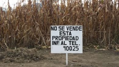
This land is NOT for sale
This is an interesting article by Frank Pichel, in which he analyzes the added value of legal certainty applied to real estate. The initial question is interesting and very true; It reminds me of my recent visit to the living zone…
Read More » -
AutoCAD-AutoDesk

My experience using Google Earth for Cadastre
I frequently see the same questions in the keywords by which users arrive at Geofumadas from the Google search engine. Can I make a cadastre using Google Earth? How accurate are Google Earth images? Because my…
Read More » -
Cadastre

III Annual Conference of the Inter-American Cadastre and Land Registry Network
Uruguay, through the National Directorate of Cadastre and the General Directorate of Registries, will host the "III Annual Conference of the Inter-American Network of Cadastre and Property Registry" to be held in…
Read More » -
Cadastre

Accurate purpose-dependent cadastre - trend, synergy, technique, or nonsense?
Back in 2009 I elaborated the systematization of the evolution of the Cadastre of a municipality, which in its natural logic suggested a progress between the reasons why it originally adopts the cadastre for tax purposes, and how that…
Read More » -
Cadastre

QGIS, PostGIS, LADM - in the Land Administration Course developed by IGAC
In the convergence of different initiatives, aspirations and challenges that Colombia is experiencing to maintain leadership in the southern cone in geospatial matters, between July 27 and August 4, the Information Research and Development Center…
Read More » -
Cadastre

How to compare changes to a CAD file
A very frequent need is to be able to know the changes that have happened to a map or plan, compared to how it was before being edited or based on time, in CAD files such as DXF, DGN and DWG. The DGN file...
Read More » -
Cadastre

What will land administration look like in the future? - vision of Cadastre 2034
Proposing what land administration could look like in 2034 does not seem like an easy idea, if we see how many changes have taken place in the last 20 years. However, the exercise is a second attempt at what has already been done 20…
Read More » -
Cadastre

Decentralization of Registry-Cadastre services in the public sector
This is the abstract of an interesting exhibition that will take place at the Annual Conference on Land and Property, sponsored by the World Bank in the coming days of March 2017. Alvarez and Ortega will present on the experience of deconcentrating services…
Read More » -
Cadastre

LADM - As Unique Model of the Land Administration Domain - Colombia
Summary of a presentation by Golgi Alvarez and Kaspar Eggenberger at the Andean Geomatics Congress in Bogotá, in June 2016. Requirement for the Multipurpose Cadastre With the entry into force of the National Development Plan 2014-2018 and the creation…
Read More »