
PlexEarth
-
AutoCAD-AutoDesk

Plex.Earth Timeviews™ empowers AEC professionals with the latest satellite imagery within AutoCAD
Plexscape, developers of Plex.Earth®, one of the most popular tools for AutoCAD for accelerating architecture, engineering, and construction (AEC) projects, launched Timeviews™, a unique service in the global AEC market, that makes the most…
Read More » -
AutoCAD-AutoDesk

Timeviews - Plugin to access historical satellite images with AutoCAD
Timeviews is an extremely interesting plugin that allows access to historical satellite images from AutoCAD, in different dates and resolutions. Having the digital contour model that I have downloaded from Google Earth, now I want to see historical images of…
Read More » -
Google earth / maps

Contour lines from Google Earth - in 3 steps
This article explains how to generate contour lines from the Google Earth digital model. For this we will use a plugin for AutoCAD. Step 1. Display the area where we want to obtain the digital model of Google Earth. He passed…
Read More » -
Geospatial - GIS

3 News and 21 important events in the GEO context - Starting 2019
Bentley, Leica and PlexEarth are among the most interesting novelties starting in February 2019. Additionally, we show that we have compiled 21 interesting events that are on the way, in which the entire community of professionals in the…
Read More » -
AutoCAD-AutoDesk

Transoft Solutions and Plexscape make alliance to offer the most realistic representation of 3D vehicles in Google Earth
Transoft Solutions Inc., a world leader in transportation engineering design and analysis software, has partnered with Plexscape, developers of Plex.Earth®, one of the most popular tools for AutoCAD for accelerating architecture, engineering, and…
Read More » -
AutoCAD-AutoDesk

My experience using Google Earth for Cadastre
I frequently see the same questions in the keywords by which users arrive at Geofumadas from the Google search engine. Can I make a cadastre using Google Earth? How accurate are Google Earth images? Because my…
Read More » -
AutoCAD-AutoDesk
Google Earth 7 limits the capture of rectified ortho images
When the new version of Plex.Earth 3 is about to come out, we realize that although it supports the loading of web map services, the great advantage it has had so far of being able to download the image of…
Read More » -
AutoCAD-AutoDesk

Plex.Earth 3.0 Load WMS services from AutoCAD
Plex.Earth 3.0 has arrived for the first time, which I have had time to test while the final version availability date is defined. Possibly in the month of November 2012. It runs with AutoCAD 2013 Perhaps the most…
Read More » -
Maps

The UTM coordinate systems displayed in Google Maps
It doesn't seem like it, but the resource that PlexScape Web Services has made available to transform coordinates and display them on Google Maps is an interesting exercise to understand how the coordinate systems of different regions of the world work. For this, it…
Read More » -
Maps
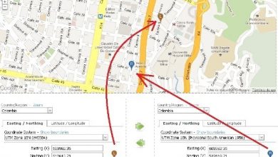
View UTM coordinates on Google Maps, and using ANY! Other coordinate system
Until now it had been common to see UTM and geographic coordinates on Google Maps. But usually keeping the datum supported by Google which is WGS84. But: What if we want to see in Google Maps, a coordinate of Colombia in MAGNA-SIRGAS, WGS72…
Read More » -
AutoCAD-AutoDesk

Plex.Earth download images from Google Earth Is it illegal?
We have already seen some programs that download images from Google Earth. Georeferenced or not, some don't exist anymore like StitchMaps and GoogleMaps Downloader. The other day a friend asked me if what Plex.Earth does from AutoCAD violates…
Read More » -
Google earth / maps

Plex.Earth, a good example of penetration in the Hispanic market
Just today the Spanish version of the PlexScape page was launched, which apart from its original edition in Greek also existed in English and French. It seems to us a significant gesture, of which we saw signs from before, well…
Read More » -
AutoCAD-AutoDesk

Geofumadas ... 2 wikileaks before 2011 ends
There are only three days left until the end of 2011, I have been authorized to communicate at least these two news that will change our lives in 2012: 1. Microsoft buys Bentley Systems. As it sounds, Microsoft has reached the final agreement...
Read More » -
Featured

A post between more than 50 months
After more than 50 months writing, this is a summary. At first glance, despite the fact that the selection has been based on page views, the x-ray is that: 13 have to do with AutoCAD or its vertical applications. A theme…
Read More » -
AutoCAD-AutoDesk

Generate Google Earth Curves with AutoCAD
Some time ago I talked about Plex.Earth Tools for AutoCAD, an interesting tool that apart from importing, creating mosaics of georeferenced images and digitizing with precision, it can also do several common routines in the area of surveying. This time I want to show...
Read More » -
AutoCAD-AutoDesk

PlexEarth, What brings 2.5 version for images of Google Earth
I have been leaked the features that the new version of PlexEarth brings, which is expected to be announced at the end of October 2011. The main reason why this tool has had a significant acceptance is that…
Read More » -
Google earth / maps

Import images and model 3D from Google Earth
Microstation, as of version 8.9 (XM) brings a series of functionalities to be able to interact with Google Earth. In this case I want to refer to the import of the three-dimensional model and its image, something similar to what AutoCAD does...
Read More » -
AutoCAD-AutoDesk

PlexEarth Tools 2.0 Beta Available
A day ago I was telling you about the news that version 2.0 of PlexEarth Tools for AutoCAD would bring, one of the most practical developments I've seen on Google Earth by a member of the AutoDesk Developer Network (ADN). …
Read More »