UNFOLDED: a new platform for spatial data management
In the 6th edition of Twingeo Magazine, we were able to give a taste of what the new platform for spatial data management offers Unfolded Studio. This innovative platform that, since February 1, 2021, has been making people talk about the potential tools it offers for the manipulation and management of large spatial data sets.
It talks about how its creators began to develop this project until it materialized in Unfolded, based on open source geospatial technologies such as kepler.gl, deck.gl and H3. A platform whose main objective is the effective management of Big Data, with an end-to-end architecture and fast iteration cycles to process large data sets. The core mechanism is based on H3 hexagonal grid capabilities.

This H3 grid is a geospatial indexing system, and with this the earth's surface is divided into hierarchical cells type tiles, each of these cells can be subdivided into others and so on. It was developed by Uber for the visualization and optimization of spatial data, and also for the management of the dynamic market -supply and demand-.
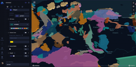
In Unfolded you can create maps with a few clicks, and from the browser. With 8 fundamental features, Unfolded Studio allows:
- Create maps effortlessly
- Great exploration display
- Powerful geospatial analysis to help users discover insights
- Cloud storage for geospatial data
- One-click map publishing
- Easy entry of geospatial data formats
- Automation to get data inside and outside the tool
- Ways to create custom applications on maps
Unfolded founders Isaac Brodsky, Ib Green, Shan He, and Sina Kashuk have been developing advanced geospatial technologies like kepler.gl, deck.gl, and H3 for over half a decade and have now joined forces to reinvent geospatial analytics.
From a Google account or by entering an email, a profile is created to start making maps. Likewise, it is possible to connect workspaces or team management tools such as "Slack". Likewise, there is a data management panel in the cloud, all the data that is uploaded to the platform is private, until the user requires to share it through a URL, chat, email, screenshot or social network (twitter , LinkedIn, Facebook or Reddit).
Business customers can access data on the Unfolded platform through the Data SDK - a REST API - through the web browser or specific commands. This SDK enables the integration of maps, data, services, and workflows. It also facilitates the creation of published maps, interactions or styles and provides control over the data that is displayed or not on a map.
When interacting with the platform, the interface and the functionalities it offers are described, as well as its difference with traditional desktop GIS such as ArcGIS or QGis for example. It combines all the power of conventional GIS with new and innovative technologies.
Unfolded Studio is not intended for traditional GIS use cases. It focuses on big data analysis and solving difficult geospatial problems from the perspective of data scientists and analysts.
Characteristics such as temporal analysis are described, essential when you have one or more datasets and you want to visualize changes in a fast and animated way. Likewise, the possibility of animating these temporal analyzes is also included in the platform.
Likewise, a note is left where the founders of Unfolded interact with their users to obtain from them a better feedback on the platform's functionalities. Likewise, they keep experimenting in order to include new tools or features that make the experience even more enriching.
On the other hand, for those who are new to Unfolded, they have the possibility to review the tutorials associated with: adding data to maps, data exploration, data union or animations. It's a platform that promises to bring big surprises to the spatial data analyst community.
It is unnecessary to invite you to read this new edition of Twingeo Magazine. We remember that we are open to receiving documents or publications that you wish to show in the magazine. Contact us through the emails editor@geofumadas.com and editor@geoingenieria.com.. The magazine is published in digital format -check it here- What are you waiting to download Twingeo? Follow us on LinkedIn for more updates.