We launched Geo-Engineering - The magazine

It is with great satisfaction that we announce the launch of Geo-engineering magazine for the Hispanic world. It will have a quarterly periodicity, enriched digital edition of multimedia content, download in pdf and printed version in the main events that are covered by its protagonists.
The main theme of this edition is the re-evaluation of the term geo-engineering, as that spectrum that includes the value chain, from the capture of the data, to the start-up of the business model that was initially conceptualized.
On its central page there is an infographic that reflects the evolution of the terms GIS, CAD, BIM, which in their historical contribution have been maturing not only the standardization trends in information management, but have also represented a common thread that is leading to re-design of the processes of the so-called "earth sciences", less and less exclusive. The spectrum in the infographic extends to that fusion of BIM+PLM in the framework of the fourth industrial revolution, for now championed by acronyms such as Digital Twins, SmartCities with a horizon that, instead of seeming distant, will surely arrive without us realizing it, as well as it has happened in Uber-Airbnb-style industries.
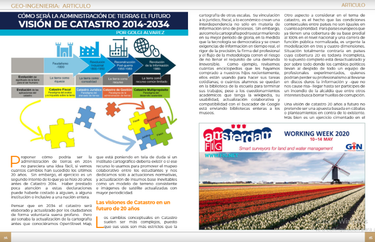
Another of the main articles includes the trends in the Land Administration, among which the 2014 Cadastre proposed, talking about achievements and challenges not yet covered in this field, whose models of natural reality should be merged with the models of the transformation caused by the human being. The trends that Cadastre 2034 aspires to are also presented in its approach to the end user with a more active role in updating and spatial data infrastructures in their link to rights, responsibilities and public order restrictions under a registry techniques approach. and not just spatial relationships.
Consequently, with these two main articles, five use cases are included; three focused on the modeling of the primary data and two on the result of adopting BIM to improve the processes of the industry.
 Plex.Earth where Lambros in an article translated into Spanish by Laura García tells us about mixed CAD-GIS solutions from the need of Civil Engineers, from the perspective of their personal history:
Plex.Earth where Lambros in an article translated by Laura García tells us about mixed CAD-GIS solutions from the need of Civil Engineers, from the perspective of their personal history:
There was no option: we had to redesign according to the reality of the terrain, affecting almost the entire installation. We lost around four months, but the numbers surprised us: in a project of 6 million dollars, the redesign cost more than $ 600,000 ... It was then that I began to develop some "simple" tools to connect AutoCAD with Google Earth, which for some time was our -secret- competitive advantage.
- e-Cassini, its founder exposes us in an interview with Shimonti Paul, how a repository of information from the topography is feasible as a truly single-point Hub.
The LiDAR topography is known today mainly by the users, too often from the technological point of view in very little emphasis from the point of view of quality, accuracy and precision. Even so, many challenges occur in terms of precision and completeness. The more accurate the spaces are described, the greater the number of users and the added value to the business model. known today mainly by the users, with too much frequency from the point of technological view in very little emphasis from the point of view of quality, accuracy and precision. Yet So, many challenges happen in terms of precision and completeness How much more Exactly describe the spaces, the greater the number of users and the added value to the model of deal.
- The president of Chasmtech explains how digital terrain models derived from satellite images are acquiring accuracies quite close to those obtained directly.
I was always curious about the accuracy of the data provided by Google. There were two possible use cases that I had in mind:
•Conceptual / preliminary design for new subdivisions.
• Access to the topography of the basin for the analysis of floodplains with HEC-RAS 2
- An interesting article by Nicolas Mangon, on the potential of connected BIM applied to the AEC context.
When you demonstrate how this connectivity, in each facet of a construction site improves efficiency, safety and cost, it will not even be a question of whether the industry will move in this direction, but how fast.
Within this thematic the magazine includes news of the leading companies in the industry; AutoDesk, Bentley Systems, Esri, Topcon, Trimble, Kadaster, Hexagon and Microsoft.
We invite you to enjoy these 60 pages of reading, while the next edition is brewing. For now, the magazine is offered in digital format, through the printing service and shipping on demand , physical format will be found in events where its protagonists participate.