
Mapserver
-
Teaching CAD / GIS

Development in Free Software as engine of change
Almost everything is ready for the 7th Conference of gvSIG Latin America and the Caribbean, which will be held in Mexico. We find valuable the gradual addition of public institutions, which for years have been controlled by proprietary software, process...
Read More » -
Geospatial - GIS

3 Magazines and 5 experiences of the geomatic field
It's time to review some magazines whose recent editions have come out; here I leave you at least interesting experiences that come out in the latest edition of these magazines. Geoinformatics 1. User experiences in the use of GIS Software…
Read More » -
Geospatial - GIS

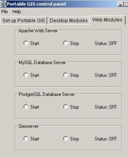
Portable GIS Version 3, almost everything from a USB
The third version of Portable GIS has been announced, a tool that we reviewed three years ago, just as version 2 was released in July 2009. By the way, I remember resorting to it back in the days…
Read More » -
GvSIG

From i3Geo and 57 Brazilian Public Software tools
Today the news of the integration of efforts between i3Geo and gvSIG has arrived, an issue that seems to me to be an important decision by the gvSIG Foundation, although I am aware that it is barely a visible result of all the work that has taken months of…
Read More » -
ArcGIS-ESRI

Geographica's GIS Pills
Geographica's friends have told us something about the innovations they are including in their training processes, so we take the opportunity to promote their initiatives. Geographica is a company dedicated to various branches of the geomatic spectrum, which has…
Read More » -
Teaching CAD / GIS

5 minutes of trust for Matías Neiff's blog
GIS, scripting and Mac are a natural combination in a blog that I have decided to recommend, because it has given me great satisfaction to find it. Reading the reasons why this blog got there makes us understand why it has stayed…
Read More » -
ArcGIS-ESRI

118 themes from FOSS4G 2010
The best that can remain from these events are the PDF presentations that are very practical for reference in training or decision-making processes; more in these times than the open source geospatial world has…
Read More » -
Maps
How Mapserver Works
Last time we talked about some criteria why MapServer and the basics of installation. Now let's see some of its operation in an exercise with the maps of the Chiapas friends. Where it is mounted Once Apache is installed, the…
Read More » -
Cadastre
Deciding by MapServer
Taking advantage of a recent conversation with a Cadastre institution that was looking for what to publish its maps with, here I summarize the most important thing to return the rescues of the subject to the community. Perhaps at the time it will serve someone who wants...
Read More » -
Teaching CAD / GIS

Aulasca, many free GIS resources
The Virtual Classroom of the Cartographic Institute of Andalusia is a platform mounted on Moodle, with which distance courses can be carried out. Apart from the multiple information services available from the Ministry of Housing and Territorial Planning,…
Read More » -
My geofumadas

…what month…
…gvSIG 1.9 stable has arrived…we are about to start assembling the IDE on mapserver…coup d'état, restitution, another coup, elections, nobody knows yet…my brother and the star biker are getting married…version 3.0 of geofumadas is almost ready. com…
Read More » -
Geospatial - GIS
Portable GIS, everything from a USB
Version 2 of Portable GIS has been released, a simply wonderful application to run from an external disk, a USB memory and even a digital camera the necessary programs for managing spatial information both at the...
Read More » -
Trips

... where are you friend ...
There are not many answers: On a trip. We choose what we do, almost everything, although I think that many things are not more complicated due to lack of time. It is satisfying to see interesting results in municipalities that with their nails and a…
Read More » -
Geospatial - GIS

Quantum GIS, first impression
The article makes a first revision of Quantum GIS, without analyzing the extensions; doing some comparisons with gvSIG and other applications
Read More » -
Geospatial - GIS
GIS software - described in 1000 words
The recent month of May, version 1.2 of this brief but admirable document was published that with that name seems to make fun of how complicated the Software is for managing spatial data. It is written by Stefan Steiniger…
Read More » -
Geospatial - GIS

Spatial Data Infrastructures for Guatemala
The Spatial Data Infrastructure Prototype for Guatemala being prepared by the Secretary General for Planning and Programming of the SEGEPLAN Presidency is interesting. We had seen in the presentation video of Moisés Poyatos and Walter Girón from SITIMI…
Read More » -
ArcGIS-ESRI
Geofumadas on the fly, January 2009
Gentlemen, these days are for running; between finishing the operating plan for this year, settling balances from what happened and socializing with mayors the scope of what the agreement on cadastral values implies in a political year… uf! getting ready...
Read More » -
Geospatial - GIS

November was gone, summary of the month
This month was less productive than the previous ones, when I had been over 40 posts, in this case I was around 28 due to the fact that the trips have been complicated and the need to finish some pending issues. Free GIS Software…
Read More »