
Geoinformatics, 7 edition ... GIS and a lot for Hispanics
The eighth edition of the Geoinformatics magazine is now available, which shines in the GIS approach at a simply "spectacular" geofumed level, although it draws our attention that on this occasion there is more than one article with an approach based on experiences from Spanish-speaking countries.
 1 GvSIG.
One of these articles with hisapno focus is an on the gvSIG project, It seems to us a good gain of visibility of an initiative that costs the tax of the people and that to follow at a fast pace could turn out to be an excellent tool of free use.
Of course, if it did not accelerate further, its development could continue to be critical by the “experts in hacking ArcGIS” who in many cases are right but who tend to lose sight because government-initiated applications often appear to be slow… or because they dislike open source.
 2 Mexico…
Another one that we are happy to see is Scanning the caves of Naica, in Mexico. An interesting article about the extreme conditions of laser scanning ...
It shows not only the methodology but some conclusions even though the work is not finished yet. In good time for our Mexican friends, the cover photo is about this article, it shows how you have to go disguised as an astronaut to make that type of captures, nothing to do with our friend from the nude beaches, hehe.
3 Web 2.0 mapping ...
 What the hell do we mean by 2.0 web ... with. Well, that is not the literal translation but it is an article that tries to smoke on the Internet trends in what we know generation 2.0.
In the pen of Lambert-Jan Koops the subject of web applications with mapping gadgets and toys and online GIS is touched upon. Interestingly, the smoker mentions products like MapGuide (AutoDesk) And ProjectWise (Bentley), Making a relationship although simplistic, clear of how these are examples of the evolution of technologies in art sharing ideas to improve collective intelligence.
You see the focus of web applications on four levels, from scratch of course:
- Level 0. They are applications that work both online and offline.
- Level 1. They are the applications that work both online and offline But they are more functional and robust working in a connected way.
- Level 2. In this case, these applications are supposed to operate on y offline, Its disconnected use is almost impossible, such is the case Google Earth.
- Level 3. This is the case of applications that only work online, As is the case of wikipedia.
Apart from this one, which seems to me to be a classic, there is another article called “Where the GIS and the virtual world meet…” interesting about virtual reality applied to GIS… although not everything can be believed to be so practical.

4. GeoBIM
Fritz Zobl and Robert Marschallinger shine Talking about Geo BIM, this time touching the approach of the topography and civil works engineering.
Also in this aspect of spatial modeling is an article that shows an integration of Remote sensors with GIS, through a spatial model of phosphorus emissions ...
5. Innovations in equipment
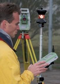 Continuing with the revision of topographic equipment Of Issue Six, In this case there is a review of the total robotic station Leica TPS 1200 +
A new generation of Jena. In this article some novelties in instruments of terrestrial observation are shown.
What new toys does Magellan bring ... It would have to see this, because Magellan with its constant sales no one knows who supports and continues to invent.
6 There is more…
I'd better recommend you read online or download it as pdf for your collection, just weigh 12 MB and download it fast.


Normally I am always involved in surveying polygonal surveys and elaborating their respective cadastral plans. So I'm interested in going deeper into the issues that have to do with my work.
End of the project in October of 2012;
The United Nations (NGO Branch - Cartography Section) carry out the LEICA station settlement special price of € 1.000 (US $ 1.211);
Shipping costs are your responsibility, vary depending on the country of purchase and payable before shipping.
The Leica robotic total stations for sale:
- 8 Leica TCRP 1205 R300 R300 1203 and TCRP
– 3 LEICA TS02 – 3”
- 4 Leica GX1230 GPS RTK
Contact email: Un.org.ngo@gmail.com
********************
Cartographic Section
United Nations - Room S-1093
Washington, W 1913
********************
It seems to me a good initiative ... which is not how they would correct it later when Google decides to integrate images of good precision, already with all the information entered by users
Speaking of Web 2 and GIS, I personally think Google's Map Maker (the online tool for adding / creating data to Google Maps street maps) is the most powerful example. Almost all of India was mapped in this way, with the contribution of thousands of people through that web page. A job that once verified and corrected will serve millions of people for a long time. A tremendous solution for emerging countries, where politicians entertain themselves by seeing how to make more money instead of contributing useful things to the society that feeds them ...
Regards!